Sharur City elevation
Sharur City (Nakhichevan, Sharur Rayon), Azerbaijan elevation is 810 meters and Sharur City elevation in feet is 2657 ft above sea level [src 1]. Sharur City is a seat of a second-order administrative division (feature code) with elevation that is 450 meters (1476 ft) bigger than average city elevation in Azerbaijan.
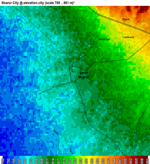
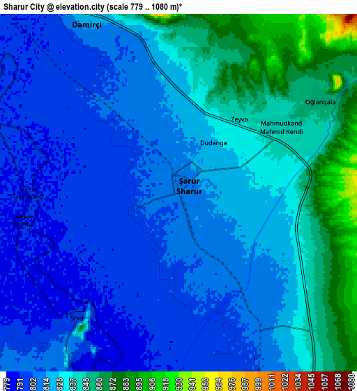
Below is the Elevation map of Sharur City, which displays elevation range with different colors. Scale of the first map is from 789 to 861 m (2589 to 2825 ft) with average elevation of 809.2 meters (=2655 ft) [note 1]
These maps also provides idea of topography and contour of this city, they are displayed at different zoom levels. More info about maps, scale and edge coordinates you can find below images.
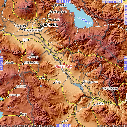
| \ | Map #1 | Map #2 | Topo.Map |
| Scale [m] | 789..861 m | 779..1080 m | × |
| Scale [ft] | 2589..2825 ft | 2556..3543 ft | × |
| Average | 809.2 m = 2655 ft | 821.6 m = 2696 ft | × |
| Width | 7.53 km = 4.7 mi | 15.07 km = 9.4 mi | 241.1 km = 149.8 mi |
| Height | 7.53 km = 4.7 mi | 15.07 km = 9.4 mi | 241.1 km = 149.8 mi |
| ↑Max Latitude | 39.586855° | 39.620714° | 40.62876° |
| Latitude at center | 39.55298° | 39.55298° | 39.55298° |
| ↓Min Latitude | 39.519088° | 39.48518° | 38.46026° |
| ← Min Longitude | 44.935985° | 44.892039° | 43.57368° |
| Longitude center | 44.97993° | 44.97993° | 44.97993° |
| →Max Longitude | 45.023875° | 45.067821° | 46.38618° |
Nearby cities:
Cities around Sharur City sort by population:
• Nakhchivan elevation 887 m
53.3 km,  135°
135°
• Culfa 714 m
87 km, 139°
• Yaycı 706 m
94 km, 136°
• Cahri 1074 m
43.8 km,  121°
121°
• Şahbuz 1196 m
53.5 km,  107°
107°
• Oğlanqala 853 m
6.8 km,  56°
56°
• Çalxanqala 1372 m
28.8 km, 115°
• Sedarak 860 m
19.7 km,  335°
335°
• Sumbatan-diza 791 m
99.1 km,  132°
132°
• Tazakend 826 m
59.5 km, 138°
• Heydarabad 818 m
22 km,  329°
329°
• Qıvraq 915 m
20.6 km,  145°
145°
Multilingual:
 En español:
Sharur City elevación 810 m.
 En France:
Sharur City élévation 810 m.
 Auf Deutsch:
Sharur City höhe über dem Meeresspiegel ist 810 m.

Sources and notes:
- [note 1] Map square and city borders are not equal. Map elevation data is calculated only from area inside that square.
- [src 1] Elevation data from geonames database provided with same terms of usage.
- [src 2] The elevation map of Sharur City is generated using elevation data from NASA's 3 arcsec (90m) resolution SRTM data.
- [src 3] Base (background) map © OpenStreetMap contributors tiles are generated by Geofabrik and OpenTopoMap.
Copyright & License:
This Sharur City Elevation Map is licensed under CC BY-SA. You may reuse any part from this page, if you give a proper credit by linking to this URL:
 More info on terms of use page.