Langenegg elevation
Langenegg (Vorarlberg, Politischer Bezirk Bregenz), Austria elevation is 729 meters and Langenegg elevation in feet is 2392 ft above sea level [src 1]. Langenegg is a populated place (feature code) with elevation that is 220 meters (722 ft) bigger than average city elevation in Austria.
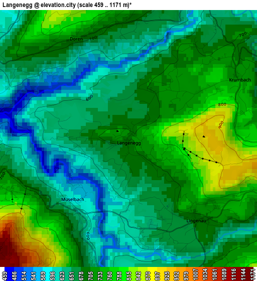
Below is the Elevation map of Langenegg, which displays elevation range with different colors. Scale of the first map is from 459 to 1171 m (1506 to 3842 ft) with average elevation of 690.4 meters (=2265 ft) [note 1]
These maps also provides idea of topography and contour of this city, they are displayed at different zoom levels. More info about maps, scale and edge coordinates you can find below images.
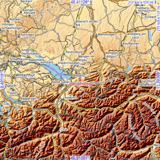
| \ | Map #1 | Topo.Map |
| Scale [m] | 459..1171 m | × |
| Scale [ft] | 1506..3842 ft | × |
| Average | 690.4 m = 2265 ft | × |
| Width | 6.61 km = 4.1 mi | 211.4 km = 131.4 mi |
| Height | 6.61 km = 4.1 mi | 211.4 km = 131.4 mi |
| ↑Max Latitude | 47.498918° | 48.41124° |
| Latitude at center | 47.46922° | 47.46922° |
| ↓Min Latitude | 47.439505° | 46.51001° |
| ← Min Longitude | 9.853495° | 8.49119° |
| Longitude center | 9.89744° | 9.89744° |
| →Max Longitude | 9.941385° | 11.30369° |
Nearby cities:
Cities around Langenegg sort by population:
• Alberschwende elevation 721 m
5.4 km,  246°
246°
• Andelsbuch 615 m
6.4 km,  182°
182°
• Egg 544 m
4.2 km, 179°
• Schwarzenberg 703 m
7 km,  209°
209°
• Hittisau 792 m
4.8 km,  105°
105°
• Lingenau 752 m
2.8 km,  139°
139°
• Sulzberg 1010 m
6 km,  11°
11°
• Langen 946 m
8 km,  311°
311°
• Großdorf 662 m
4.2 km,  161°
161°
• Riefensberg 758 m
5.8 km,  52°
52°
• Krumbach 730 m
3.3 km,  61°
61°
• Doren 706 m
2.9 km,  333°
333°
Multilingual:
 En español:
Langenegg elevación 729 m.
 En France:
Langenegg élévation 729 m.
 Auf Deutsch:
Langenegg höhe über dem Meeresspiegel ist 729 m.

Sources and notes:
- [note 1] Map square and city borders are not equal. Map elevation data is calculated only from area inside that square.
- [src 1] Elevation data from geonames database provided with same terms of usage.
- [src 2] The elevation map of Langenegg is generated using elevation data from NASA's 3 arcsec (90m) resolution SRTM data.
- [src 3] Base (background) map © OpenStreetMap contributors tiles are generated by Geofabrik and OpenTopoMap.
Copyright & License:
This Langenegg Elevation Map is licensed under CC BY-SA. You may reuse any part from this page, if you give a proper credit by linking to this URL:
 More info on terms of use page.