Unterjosefstal elevation
Unterjosefstal (Upper Austria, Politischer Bezirk Perg), Austria elevation is 268 meters and Unterjosefstal elevation in feet is 879 ft above sea level [src 1]. Unterjosefstal is a seat of a third-order administrative division (feature code) with elevation that is 241 meters (791 ft) smaller than average city elevation in Austria.
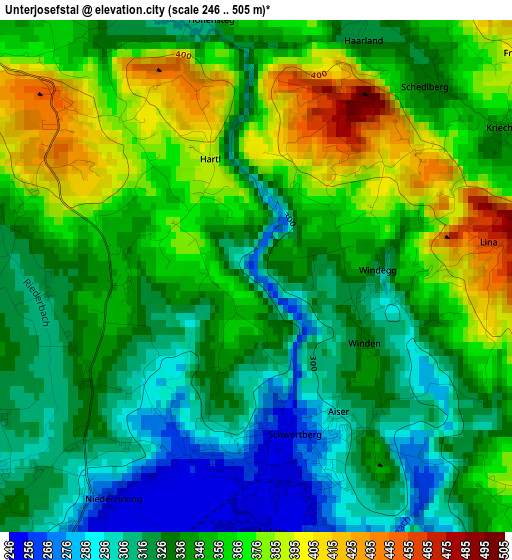
Below is the Elevation map of Unterjosefstal, which displays elevation range with different colors. Scale of the first map is from 246 to 505 m (807 to 1657 ft) with average elevation of 344.2 meters (=1129 ft) [note 1]
These maps also provides idea of topography and contour of this city, they are displayed at different zoom levels. More info about maps, scale and edge coordinates you can find below images.
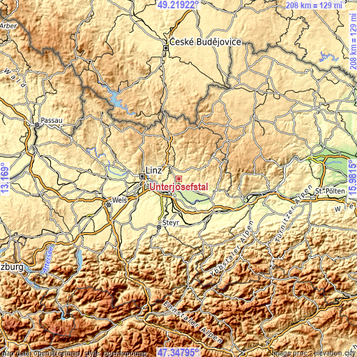
| \ | Map #1 | Topo.Map |
| Scale [m] | 246..505 m | × |
| Scale [ft] | 807..1657 ft | × |
| Average | 344.2 m = 1129 ft | × |
| Width | 6.5 km = 4 mi | 208.1 km = 129.3 mi |
| Height | 6.5 km = 4 mi | 208.1 km = 129.3 mi |
| ↑Max Latitude | 48.32139° | 49.21922° |
| Latitude at center | 48.29216° | 48.29216° |
| ↓Min Latitude | 48.262913° | 47.34795° |
| ← Min Longitude | 14.531305° | 13.169° |
| Longitude center | 14.57525° | 14.57525° |
| →Max Longitude | 14.619195° | 15.9815° |
Nearby cities:
Cities around Unterjosefstal sort by population:
• Perg elevation 252 m
6.4 km,  137°
137°
• Schwertberg 264 m
2.2 km,  161°
161°
• Pregarten 423 m
7.7 km,  335°
335°
• Ufer 231 m
7.4 km,  228°
228°
• Naarn im Machlande 243 m
7.8 km, 161°
• Tragwein 484 m
5.7 km,  37°
37°
• Ried in der Riedmark 303 m
4.2 km,  236°
236°
• Windhaag bei Perg 517 m
7.8 km,  95°
95°
• Allerheiligen im Mühlkreis 553 m
5.7 km,  78°
78°
• Doppl 337 m
1.2 km,  204°
204°
• Loitzenberg 309 m
2.7 km,  218°
218°
• Wasserburg 264 m
2.2 km,  207°
207°
Multilingual:
 En español:
Unterjosefstal elevación 268 m.
 En France:
Unterjosefstal élévation 268 m.
 Auf Deutsch:
Unterjosefstal höhe über dem Meeresspiegel ist 268 m.

Sources and notes:
- [note 1] Map square and city borders are not equal. Map elevation data is calculated only from area inside that square.
- [src 1] Elevation data from geonames database provided with same terms of usage.
- [src 2] The elevation map of Unterjosefstal is generated using elevation data from NASA's 3 arcsec (90m) resolution SRTM data.
- [src 3] Base (background) map © OpenStreetMap contributors tiles are generated by Geofabrik and OpenTopoMap.
Copyright & License:
This Unterjosefstal Elevation Map is licensed under CC BY-SA. You may reuse any part from this page, if you give a proper credit by linking to this URL:
 More info on terms of use page.