Frastanz elevation
Frastanz (Vorarlberg, Politischer Bezirk Feldkirch), Austria elevation is 494 meters and Frastanz elevation in feet is 1621 ft above sea level [src 1]. Frastanz is a populated place (feature code) with elevation that is 15 meters (49 ft) smaller than average city elevation in Austria.
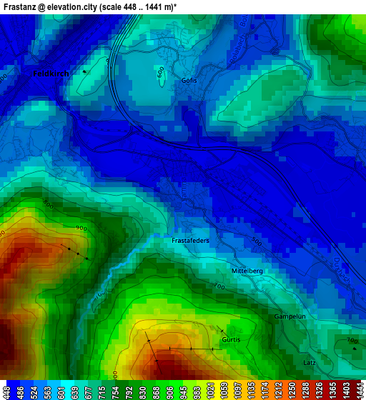
Below is the Elevation map of Frastanz, which displays elevation range with different colors. Scale of the first map is from 448 to 1441 m (1470 to 4728 ft) with average elevation of 674.9 meters (=2214 ft) [note 1]
These maps also provides idea of topography and contour of this city, they are displayed at different zoom levels. More info about maps, scale and edge coordinates you can find below images.
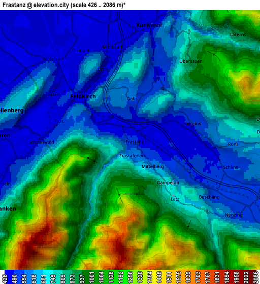
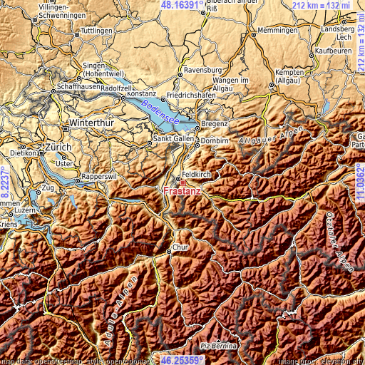
| \ | Map #1 | Map #2 | Topo.Map |
| Scale [m] | 448..1441 m | 426..2086 m | × |
| Scale [ft] | 1470..4728 ft | 1398..6844 ft | × |
| Average | 674.9 m = 2214 ft | 811.6 m = 2663 ft | × |
| Width | 6.64 km = 4.1 mi | 13.28 km = 8.3 mi | 212.4 km = 132 mi |
| Height | 6.64 km = 4.1 mi | 13.28 km = 8.3 mi | 212.4 km = 132 mi |
| ↑Max Latitude | 47.24719° | 47.277013° | 48.16391° |
| Latitude at center | 47.21735° | 47.21735° | 47.21735° |
| ↓Min Latitude | 47.187493° | 47.157619° | 46.25359° |
| ← Min Longitude | 9.586005° | 9.542059° | 8.2237° |
| Longitude center | 9.62995° | 9.62995° | 9.62995° |
| →Max Longitude | 9.673895° | 9.717841° | 11.0362° |
Nearby cities:
Cities around Frastanz sort by population:
• Feldkirch elevation 475 m
2.9 km,  307°
307°
• Rankweil 471 m
6.1 km,  9°
9°
• Nenzing 527 m
6.8 km,  122°
122°
• Göfis 530 m
1.8 km, 10°
• Satteins 479 m
2.8 km,  91°
91°
• Schlins 499 m
5.6 km,  110°
110°
• Muntlix 491 m
7.6 km,  16°
16°
• Batschuns 478 m
7.5 km, 11°
• Übersaxen 897 m
5 km,  38°
38°
• Düns 778 m
6.6 km,  84°
84°
• Röns 615 m
5.3 km, 90°
• Dünserberg 1057 m
7.2 km, 80°
Multilingual:
 En español:
Frastanz elevación 494 m.
 En France:
Frastanz élévation 494 m.
 Auf Deutsch:
Frastanz höhe über dem Meeresspiegel ist 494 m.

Sources and notes:
- [note 1] Map square and city borders are not equal. Map elevation data is calculated only from area inside that square.
- [src 1] Elevation data from geonames database provided with same terms of usage.
- [src 2] The elevation map of Frastanz is generated using elevation data from NASA's 3 arcsec (90m) resolution SRTM data.
- [src 3] Base (background) map © OpenStreetMap contributors tiles are generated by Geofabrik and OpenTopoMap.
Copyright & License:
This Frastanz Elevation Map is licensed under CC BY-SA. You may reuse any part from this page, if you give a proper credit by linking to this URL:
 More info on terms of use page.