Mellau elevation
Mellau (Vorarlberg, Politischer Bezirk Bregenz), Austria elevation is 689 meters and Mellau elevation in feet is 2260 ft above sea level [src 1]. Mellau is a populated place (feature code) with elevation that is 180 meters (591 ft) bigger than average city elevation in Austria.
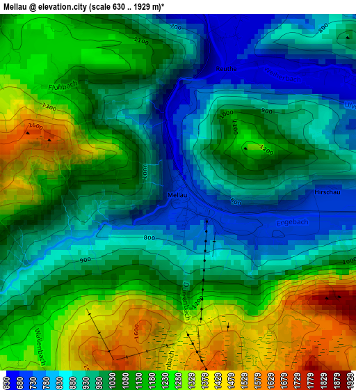
Below is the Elevation map of Mellau, which displays elevation range with different colors. Scale of the first map is from 630 to 1929 m (2067 to 6329 ft) with average elevation of 1067.8 meters (=3503 ft) [note 1]
These maps also provides idea of topography and contour of this city, they are displayed at different zoom levels. More info about maps, scale and edge coordinates you can find below images.
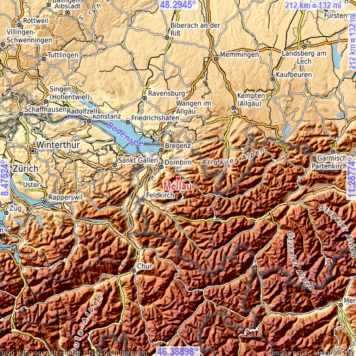
| \ | Map #1 | Topo.Map |
| Scale [m] | 630..1929 m | × |
| Scale [ft] | 2067..6329 ft | × |
| Average | 1067.8 m = 3503 ft | × |
| Width | 6.62 km = 4.1 mi | 211.9 km = 131.7 mi |
| Height | 6.62 km = 4.1 mi | 211.9 km = 131.7 mi |
| ↑Max Latitude | 47.380105° | 48.2945° |
| Latitude at center | 47.35034° | 47.35034° |
| ↓Min Latitude | 47.320558° | 46.38898° |
| ← Min Longitude | 9.837545° | 8.47524° |
| Longitude center | 9.88149° | 9.88149° |
| →Max Longitude | 9.925435° | 11.28774° |
Nearby cities:
Cities around Mellau sort by population:
• Andelsbuch elevation 615 m
6.9 km,  7°
7°
• Egg 544 m
9.1 km, 7°
• Bezau 651 m
4.1 km,  21°
21°
• Schwarzenberg 703 m
7.4 km,  342°
342°
• Lingenau 752 m
11.5 km, 15°
• Großdorf 662 m
9.6 km, 15°
• Bizau 682 m
4.1 km,  59°
59°
• Au 819 m
8.1 km,  113°
113°
• Schoppernau 839 m
11 km, 112°
• Reuthe 647 m
2.5 km, 23°
• Damüls 1402 m
7.8 km,  174°
174°
• Schnepfau 738 m
4.8 km,  87°
87°
Multilingual:
 En español:
Mellau elevación 689 m.
 En France:
Mellau élévation 689 m.


Sources and notes:
- [note 1] Map square and city borders are not equal. Map elevation data is calculated only from area inside that square.
- [src 1] Elevation data from geonames database provided with same terms of usage.
- [src 2] The elevation map of Mellau is generated using elevation data from NASA's 3 arcsec (90m) resolution SRTM data.
- [src 3] Base (background) map © OpenStreetMap contributors tiles are generated by Geofabrik and OpenTopoMap.
Copyright & License:
This Mellau Elevation Map is licensed under CC BY-SA. You may reuse any part from this page, if you give a proper credit by linking to this URL:
 More info on terms of use page.