Kleinedling elevation
Kleinedling (Carinthia, Politischer Bezirk Wolfsberg), Austria elevation is 439 meters and Kleinedling elevation in feet is 1440 ft above sea level [src 1]. Kleinedling is a populated place (feature code) with elevation that is 70 meters (230 ft) smaller than average city elevation in Austria.
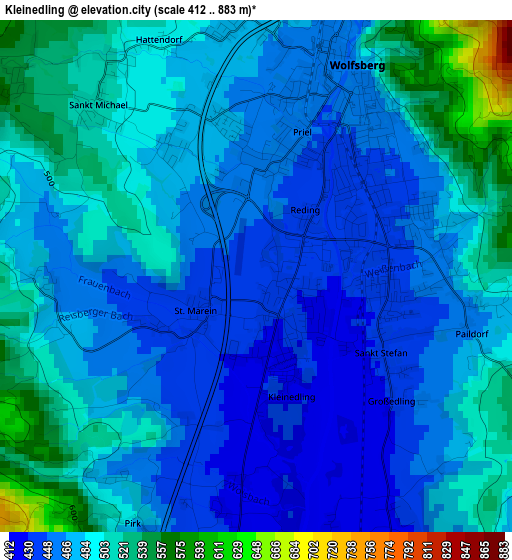
Below is the Elevation map of Kleinedling, which displays elevation range with different colors. Scale of the first map is from 412 to 883 m (1352 to 2897 ft) with average elevation of 479.6 meters (=1573 ft) [note 1]
These maps also provides idea of topography and contour of this city, they are displayed at different zoom levels. More info about maps, scale and edge coordinates you can find below images.
| \ | Map #1 | Topo.Map |
| Scale [m] | 412..883 m | × |
| Scale [ft] | 1352..2897 ft | × |
| Average | 479.6 m = 1573 ft | × |
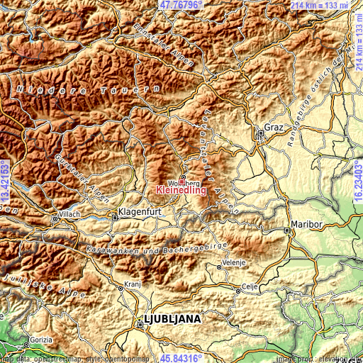
| Width | 6.69 km = 4.2 mi | 214 km = 133 mi |
| Height | 6.69 km = 4.2 mi | 214 km = 133 mi |
| ↑Max Latitude | 46.844236° | 47.76796° |
| Latitude at center | 46.81417° | 46.81417° |
| ↓Min Latitude | 46.784087° | 45.84316° |
| ← Min Longitude | 14.783835° | 13.42153° |
| Longitude center | 14.82778° | 14.82778° |
| →Max Longitude | 14.871725° | 16.23403° |
Nearby cities:
Cities around Kleinedling sort by population:
• Priel elevation 452 m
1.5 km,  15°
15°
• Reding 443 m
1.7 km,  80°
80°
• Bad Sankt Leonhard im Lavanttal 707 m
16.8 km,  350°
350°
• Sankt Stefan 435 m
2 km,  112°
112°
• Sankt Paul im Levanttal 380 m
13.1 km,  163°
163°
• Sankt Andrä 430 m
5.1 km,  186°
186°
• Gries 460 m
2.6 km,  42°
42°
• Griffen 486 m
14.2 km,  210°
210°
• Wolfsberg 461 m
3.2 km, 23°
• Diex 1016 m
18.8 km,  247°
247°
• Preitenegg 1069 m
15.9 km,  28°
28°
• Ruden 570 m
17.8 km, 192°
Multilingual:
 En español:
Kleinedling elevación 439 m.
 En France:
Kleinedling élévation 439 m.
 Auf Deutsch:
Kleinedling höhe über dem Meeresspiegel ist 439 m.

Sources and notes:
- [note 1] Map square and city borders are not equal. Map elevation data is calculated only from area inside that square.
- [src 1] Elevation data from geonames database provided with same terms of usage.
- [src 2] The elevation map of Kleinedling is generated using elevation data from NASA's 3 arcsec (90m) resolution SRTM data.
- [src 3] Base (background) map © OpenStreetMap contributors tiles are generated by Geofabrik and OpenTopoMap.
Copyright & License:
This Kleinedling Elevation Map is licensed under CC BY-SA. You may reuse any part from this page, if you give a proper credit by linking to this URL:
 More info on terms of use page.