Absam elevation
Absam (Tyrol, Politischer Bezirk Innsbruck Land), Austria elevation is 650 meters and Absam elevation in feet is 2133 ft above sea level [src 1]. Absam is a seat of a third-order administrative division (feature code) with elevation that is 141 meters (463 ft) bigger than average city elevation in Austria.
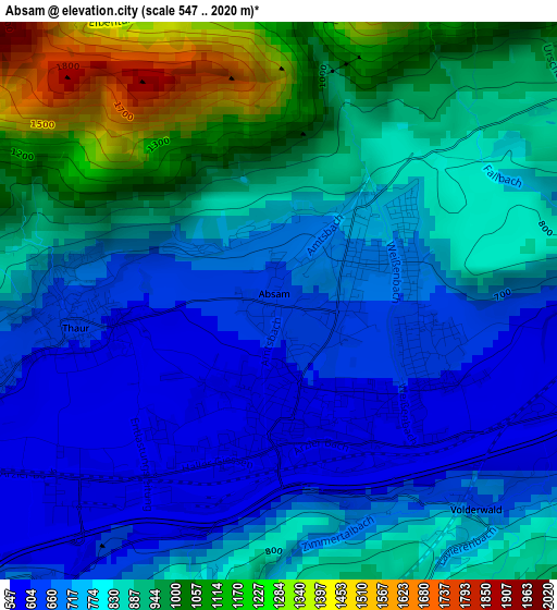
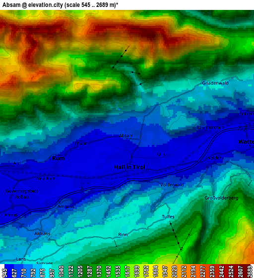
Below is the Elevation map of Absam, which displays elevation range with different colors. Scale of the first map is from 547 to 2020 m (1795 to 6627 ft) with average elevation of 818 meters (=2684 ft) [note 1]
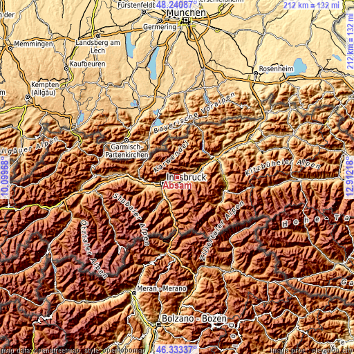
These maps also provides idea of topography and contour of this city, they are displayed at different zoom levels. More info about maps, scale and edge coordinates you can find below images.
| \ | Map #1 | Map #2 | Topo.Map |
| Scale [m] | 547..2020 m | 545..2689 m | × |
| Scale [ft] | 1795..6627 ft | 1788..8822 ft | × |
| Average | 818 m = 2684 ft | 1151.1 m = 3777 ft | × |
| Width | 6.63 km = 4.1 mi | 13.26 km = 8.2 mi | 212.1 km = 131.8 mi |
| Height | 6.63 km = 4.1 mi | 13.26 km = 8.2 mi | 212.1 km = 131.8 mi |
| ↑Max Latitude | 47.325516° | 47.355295° | 48.24087° |
| Latitude at center | 47.29572° | 47.29572° | 47.29572° |
| ↓Min Latitude | 47.265907° | 47.236078° | 46.33337° |
| ← Min Longitude | 11.461985° | 11.418039° | 10.09968° |
| Longitude center | 11.50593° | 11.50593° | 11.50593° |
| →Max Longitude | 11.549875° | 11.593821° | 12.91218° |
Nearby cities:
Cities around Absam sort by population:
• Hall in Tirol elevation 587 m
1.6 km,  149°
149°
• Arzl 638 m
5.6 km,  255°
255°
• Rum 623 m
4.4 km,  251°
251°
• Mils bei Solbad Hall 578 m
2.5 km,  123°
123°
• Thaur 599 m
2.3 km,  267°
267°
• Volders 583 m
4.8 km,  106°
106°
• Fritzens 549 m
6.4 km,  80°
80°
• Rinn 907 m
5.1 km,  185°
185°
• Ampass 636 m
4.9 km,  221°
221°
• Baumkirchen 582 m
4.6 km, 84°
• Tulfes 912 m
4.7 km, 153°
• Gnadenwald 859 m
5.1 km,  63°
63°
Multilingual:
 En español:
Absam elevación 650 m.
 En France:
Absam élévation 650 m.


Sources and notes:
- [note 1] Map square and city borders are not equal. Map elevation data is calculated only from area inside that square.
- [src 1] Elevation data from geonames database provided with same terms of usage.
- [src 2] The elevation map of Absam is generated using elevation data from NASA's 3 arcsec (90m) resolution SRTM data.
- [src 3] Base (background) map © OpenStreetMap contributors tiles are generated by Geofabrik and OpenTopoMap.
Copyright & License:
This Absam Elevation Map is licensed under CC BY-SA. You may reuse any part from this page, if you give a proper credit by linking to this URL:
 More info on terms of use page.