Altmünster elevation
Altmünster (Upper Austria, Politischer Bezirk Gmunden), Austria elevation is 448 meters and Altmünster elevation in feet is 1470 ft above sea level [src 1]. Altmünster is a populated place (feature code) with elevation that is 61 meters (200 ft) smaller than average city elevation in Austria.
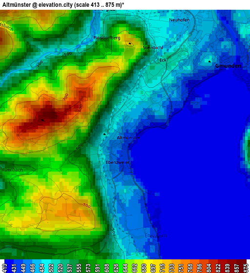
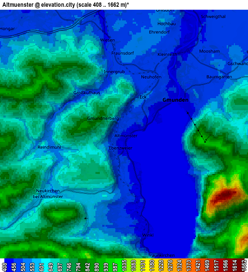
Below is the Elevation map of Altmünster, which displays elevation range with different colors. Scale of the first map is from 413 to 875 m (1355 to 2871 ft) with average elevation of 536.8 meters (=1761 ft) [note 1]
These maps also provides idea of topography and contour of this city, they are displayed at different zoom levels. More info about maps, scale and edge coordinates you can find below images.
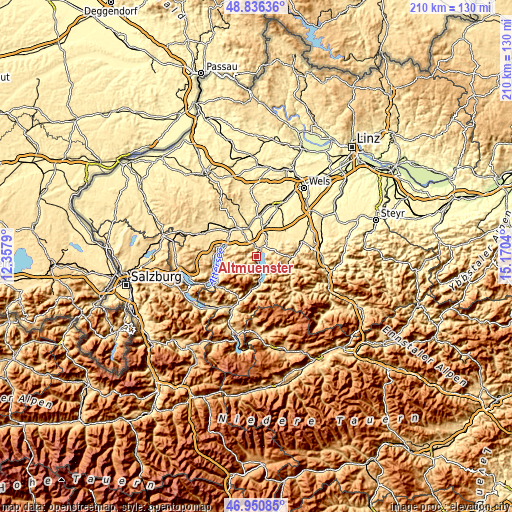
| \ | Map #1 | Map #2 | Topo.Map |
| Scale [m] | 413..875 m | 408..1662 m | × |
| Scale [ft] | 1355..2871 ft | 1339..5453 ft | × |
| Average | 536.8 m = 1761 ft | 609.2 m = 1999 ft | × |
| Width | 6.55 km = 4.1 mi | 13.1 km = 8.1 mi | 209.6 km = 130.2 mi |
| Height | 6.55 km = 4.1 mi | 13.1 km = 8.1 mi | 209.6 km = 130.2 mi |
| ↑Max Latitude | 47.931642° | 47.961078° | 48.83636° |
| Latitude at center | 47.90219° | 47.90219° | 47.90219° |
| ↓Min Latitude | 47.872721° | 47.843235° | 46.95085° |
| ← Min Longitude | 13.720205° | 13.676259° | 12.3579° |
| Longitude center | 13.76415° | 13.76415° | 13.76415° |
| →Max Longitude | 13.808095° | 13.852041° | 15.1704° |
Nearby cities:
Cities around Altmünster sort by population:
• Gmunden elevation 434 m
3.2 km,  55°
55°
• Laakirchen 439 m
9.8 km,  25°
25°
• Attnang-Puchheim 417 m
12.3 km,  343°
343°
• Ebensee 423 m
10.6 km,  174°
174°
• Puchheim 405 m
11.4 km, 341°
• Neukirchen 561 m
5 km,  232°
232°
• Gschwandt 519 m
7.1 km, 58°
• Traunkirchen 433 m
6.7 km,  163°
163°
• Pinsdorf 492 m
3.1 km,  9°
9°
• Ohlsdorf 533 m
6.8 km,  17°
17°
• Regau 429 m
11.4 km,  330°
330°
• Aurach am Hongar 492 m
8.8 km,  309°
309°
Multilingual:
 En español:
Altmünster elevación 448 m.
 En France:
Altmünster élévation 448 m.
 Auf Deutsch:
Altmünster höhe über dem Meeresspiegel ist 448 m.

Sources and notes:
- [note 1] Map square and city borders are not equal. Map elevation data is calculated only from area inside that square.
- [src 1] Elevation data from geonames database provided with same terms of usage.
- [src 2] The elevation map of Altmünster is generated using elevation data from NASA's 3 arcsec (90m) resolution SRTM data.
- [src 3] Base (background) map © OpenStreetMap contributors tiles are generated by Geofabrik and OpenTopoMap.
Copyright & License:
This Altmünster Elevation Map is licensed under CC BY-SA. You may reuse any part from this page, if you give a proper credit by linking to this URL:
 More info on terms of use page.