Andau elevation
Andau (Burgenland, Politischer Bezirk Neusiedl am See), Austria elevation is 118 meters and Andau elevation in feet is 387 ft above sea level [src 1]. Andau is a seat of a third-order administrative division (feature code) with elevation that is 391 meters (1283 ft) smaller than average city elevation in Austria.
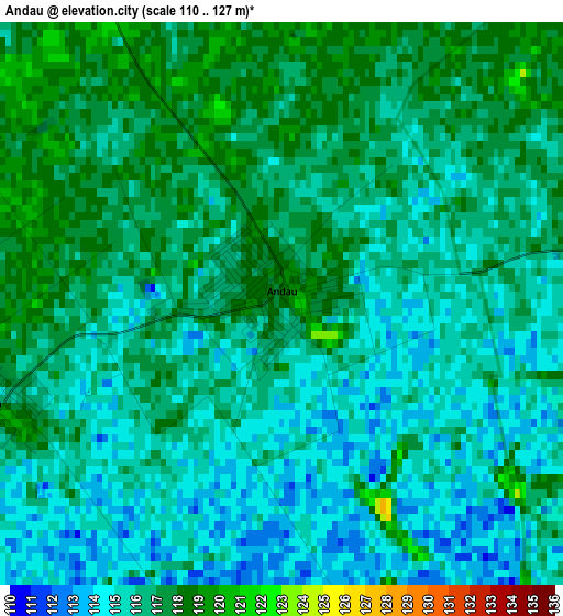
Below is the Elevation map of Andau, which displays elevation range with different colors. Scale of the first map is from 110 to 127 m (361 to 417 ft) with average elevation of 115.9 meters (=380 ft) [note 1]
These maps also provides idea of topography and contour of this city, they are displayed at different zoom levels. More info about maps, scale and edge coordinates you can find below images.
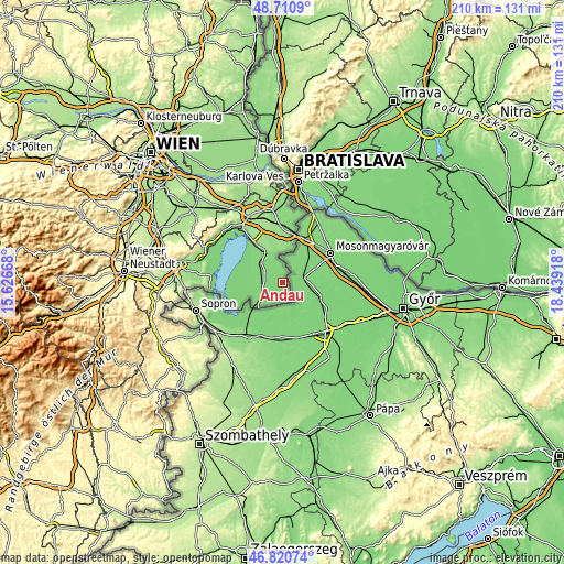
| \ | Map #1 | Topo.Map |
| Scale [m] | 110..127 m | × |
| Scale [ft] | 361..417 ft | × |
| Average | 115.9 m = 380 ft | × |
| Width | 6.57 km = 4.1 mi | 210.2 km = 130.6 mi |
| Height | 6.57 km = 4.1 mi | 210.2 km = 130.6 mi |
| ↑Max Latitude | 47.803935° | 48.7109° |
| Latitude at center | 47.77441° | 47.77441° |
| ↓Min Latitude | 47.744868° | 46.82074° |
| ← Min Longitude | 16.988985° | 15.62668° |
| Longitude center | 17.03293° | 17.03293° |
| →Max Longitude | 17.076875° | 18.43918° |
Nearby cities:
Cities around Andau sort by population:
• Gols elevation 126 m
16.4 km,  326°
326°
• Frauenkirchen 126 m
10.6 km,  310°
310°
• Illmitz 120 m
17.4 km,  265°
265°
• Mönchhof 128 m
13.6 km, 329°
• Podersdorf am See 120 m
17.1 km,  301°
301°
• Halbturn 126 m
11.5 km,  338°
338°
• Nickelsdorf 139 m
18.7 km,  8°
8°
• Apetlon 120 m
15.5 km,  257°
257°
• Wallern im Burgenland 118 m
8.8 km,  234°
234°
• Pamhagen 121 m
12.4 km, 228°
• Sankt Andrä am Zicksee 124 m
6.9 km,  279°
279°
• Tadten 119 m
3.8 km, 256°
Multilingual:
 En español:
Andau elevación 118 m.
 En France:
Andau élévation 118 m.


Sources and notes:
- [note 1] Map square and city borders are not equal. Map elevation data is calculated only from area inside that square.
- [src 1] Elevation data from geonames database provided with same terms of usage.
- [src 2] The elevation map of Andau is generated using elevation data from NASA's 3 arcsec (90m) resolution SRTM data.
- [src 3] Base (background) map © OpenStreetMap contributors tiles are generated by Geofabrik and OpenTopoMap.
Copyright & License:
This Andau Elevation Map is licensed under CC BY-SA. You may reuse any part from this page, if you give a proper credit by linking to this URL:
 More info on terms of use page.