Atzbach elevation
Atzbach (Upper Austria, Politischer Bezirk Vöcklabruck), Austria elevation is 466 meters and Atzbach elevation in feet is 1529 ft above sea level [src 1]. Atzbach is a seat of a third-order administrative division (feature code) with elevation that is 43 meters (141 ft) smaller than average city elevation in Austria.
Below is the Elevation map of Atzbach, which displays elevation range with different colors. Scale of the first map is from 395 to 686 m (1296 to 2251 ft) with average elevation of 478.2 meters (=1569 ft) [note 1]
These maps also provides idea of topography and contour of this city, they are displayed at different zoom levels. More info about maps, scale and edge coordinates you can find below images.
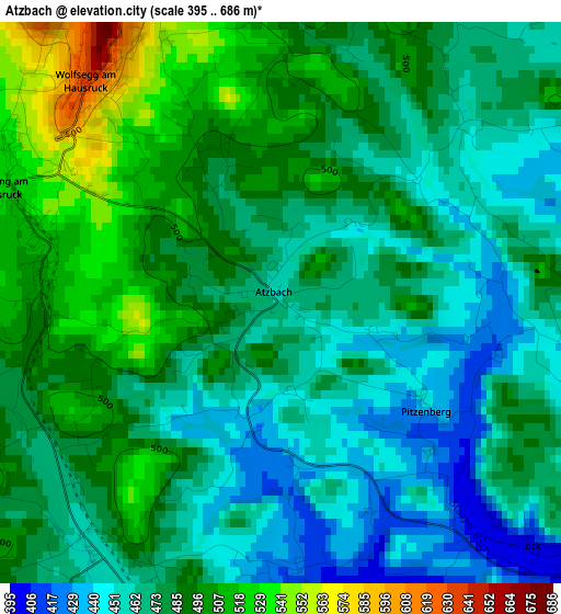
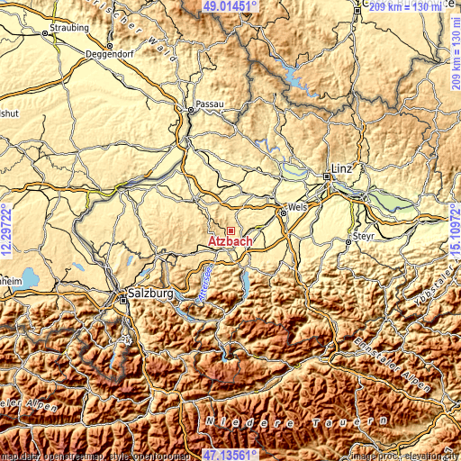
| \ | Map #1 | Topo.Map |
| Scale [m] | 395..686 m | × |
| Scale [ft] | 1296..2251 ft | × |
| Average | 478.2 m = 1569 ft | × |
| Width | 6.53 km = 4.1 mi | 208.9 km = 129.8 mi |
| Height | 6.53 km = 4.1 mi | 208.9 km = 129.8 mi |
| ↑Max Latitude | 48.112989° | 49.01451° |
| Latitude at center | 48.08364° | 48.08364° |
| ↓Min Latitude | 48.054274° | 47.13561° |
| ← Min Longitude | 13.659525° | 12.29722° |
| Longitude center | 13.70347° | 13.70347° |
| →Max Longitude | 13.747415° | 15.10972° |
Nearby cities:
Cities around Atzbach sort by population:
• Schwanenstadt elevation 390 m
6.2 km,  120°
120°
• Gaspoltshofen 451 m
7.1 km,  20°
20°
• Ottnang am Hausruck 525 m
3.6 km,  291°
291°
• Wolfsegg am Hausruck 633 m
3.4 km,  318°
318°
• Oberndorf bei Schwanenstadt 392 m
5 km,  128°
128°
• Niederthalheim 426 m
5.1 km,  70°
70°
• Schlatt 404 m
6.5 km,  101°
101°
• Aichkirchen 446 m
7.1 km, 66°
• Manning 509 m
2.8 km,  281°
281°
• Pitzenberg 443 m
1.9 km, 125°
• Pühret 437 m
5.6 km,  165°
165°
• Rutzenham 409 m
2.8 km,  155°
155°
Multilingual:
 En español:
Atzbach elevación 466 m.
 En France:
Atzbach élévation 466 m.


Sources and notes:
- [note 1] Map square and city borders are not equal. Map elevation data is calculated only from area inside that square.
- [src 1] Elevation data from geonames database provided with same terms of usage.
- [src 2] The elevation map of Atzbach is generated using elevation data from NASA's 3 arcsec (90m) resolution SRTM data.
- [src 3] Base (background) map © OpenStreetMap contributors tiles are generated by Geofabrik and OpenTopoMap.
Copyright & License:
This Atzbach Elevation Map is licensed under CC BY-SA. You may reuse any part from this page, if you give a proper credit by linking to this URL:
 More info on terms of use page.