Bludenz elevation
Bludenz (Vorarlberg, Politischer Bezirk Bludenz), Austria elevation is 567 meters and Bludenz elevation in feet is 1860 ft above sea level [src 1]. Bludenz is a seat of a second-order administrative division (feature code) with elevation that is 58 meters (190 ft) bigger than average city elevation in Austria.
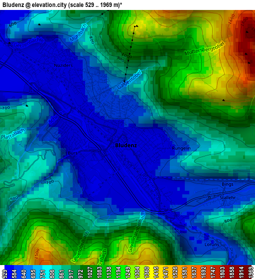
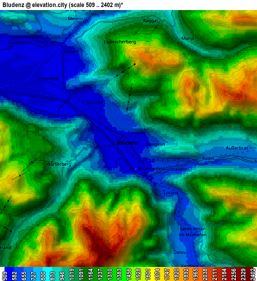
Below is the Elevation map of Bludenz, which displays elevation range with different colors. Scale of the first map is from 529 to 1969 m (1736 to 6460 ft) with average elevation of 861.4 meters (=2826 ft) [note 1]
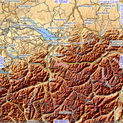
These maps also provides idea of topography and contour of this city, they are displayed at different zoom levels. More info about maps, scale and edge coordinates you can find below images.
| \ | Map #1 | Map #2 | Topo.Map |
| Scale [m] | 529..1969 m | 509..2402 m | × |
| Scale [ft] | 1736..6460 ft | 1670..7881 ft | × |
| Average | 861.4 m = 2826 ft | 1111.9 m = 3648 ft | × |
| Width | 6.65 km = 4.1 mi | 13.29 km = 8.3 mi | 212.7 km = 132.2 mi |
| Height | 6.65 km = 4.1 mi | 13.29 km = 8.3 mi | 212.6 km = 132.1 mi |
| ↑Max Latitude | 47.184635° | 47.214494° | 48.10244° |
| Latitude at center | 47.15476° | 47.15476° | 47.15476° |
| ↓Min Latitude | 47.124868° | 47.094959° | 46.18987° |
| ← Min Longitude | 9.778605° | 9.734659° | 8.4163° |
| Longitude center | 9.82255° | 9.82255° | 9.82255° |
| →Max Longitude | 9.866495° | 9.910441° | 11.2288° |
Nearby cities:
Cities around Bludenz sort by population:
• Nüziders elevation 549 m
2.2 km,  307°
307°
• Ludesch 657 m
5.8 km,  329°
329°
• Bürs 580 m
1.8 km,  251°
251°
• Vandans 644 m
7.3 km,  153°
153°
• Thüringen 561 m
6.6 km,  319°
319°
• Ausserbraz 718 m
5.9 km,  96°
96°
• Innerbraz 827 m
7.1 km,  94°
94°
• Sankt Anton im Montafon 706 m
5.4 km,  141°
141°
• Raggal 1011 m
6.3 km,  9°
9°
• Bürserberg 872 m
3.5 km, 254°
• Lorüns 653 m
3.2 km, 139°
• Stallehr 653 m
3.2 km, 139°
Multilingual:
 En español:
Bludenz elevación 567 m.
 En France:
Bludenz élévation 567 m.


Sources and notes:
- [note 1] Map square and city borders are not equal. Map elevation data is calculated only from area inside that square.
- [src 1] Elevation data from geonames database provided with same terms of usage.
- [src 2] The elevation map of Bludenz is generated using elevation data from NASA's 3 arcsec (90m) resolution SRTM data.
- [src 3] Base (background) map © OpenStreetMap contributors tiles are generated by Geofabrik and OpenTopoMap.
Copyright & License:
This Bludenz Elevation Map is licensed under CC BY-SA. You may reuse any part from this page, if you give a proper credit by linking to this URL:
 More info on terms of use page.