Bürmoos elevation
Bürmoos (Salzburg, Politischer Bezirk Salzburg-Umgebung), Austria elevation is 434 meters and Bürmoos elevation in feet is 1424 ft above sea level [src 1]. Bürmoos is a populated place (feature code) with elevation that is 75 meters (246 ft) smaller than average city elevation in Austria.
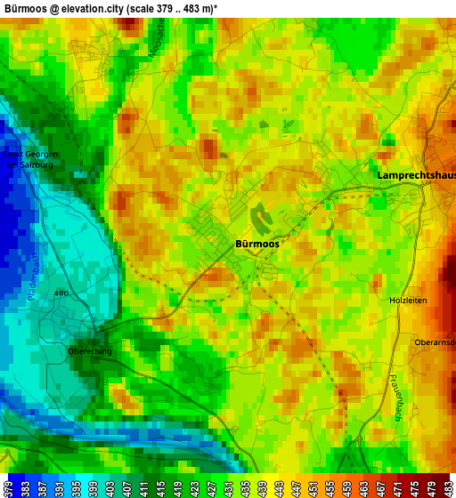
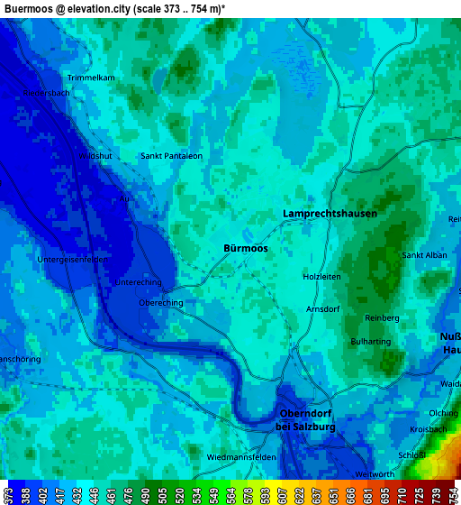
Below is the Elevation map of Bürmoos, which displays elevation range with different colors. Scale of the first map is from 379 to 483 m (1243 to 1585 ft) with average elevation of 431.6 meters (=1416 ft) [note 1]
These maps also provides idea of topography and contour of this city, they are displayed at different zoom levels. More info about maps, scale and edge coordinates you can find below images.
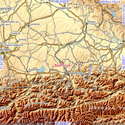
| \ | Map #1 | Map #2 | Topo.Map |
| Scale [m] | 379..483 m | 373..754 m | × |
| Scale [ft] | 1243..1585 ft | 1224..2474 ft | × |
| Average | 431.6 m = 1416 ft | 434 m = 1424 ft | × |
| Width | 6.54 km = 4.1 mi | 13.08 km = 8.1 mi | 209.3 km = 130.1 mi |
| Height | 6.54 km = 4.1 mi | 13.08 km = 8.1 mi | 209.3 km = 130.1 mi |
| ↑Max Latitude | 48.012836° | 48.042226° | 48.91613° |
| Latitude at center | 47.98343° | 47.98343° | 47.98343° |
| ↓Min Latitude | 47.954007° | 47.924567° | 47.03357° |
| ← Min Longitude | 12.873915° | 12.829969° | 11.51161° |
| Longitude center | 12.91786° | 12.91786° | 12.91786° |
| →Max Longitude | 12.961805° | 13.005751° | 14.32411° |
Nearby cities:
Cities around Bürmoos sort by population:
• Oberndorf bei Salzburg elevation 430 m
3.9 km,  162°
162°
• Obertrum am See 508 m
12.9 km,  113°
113°
• Ostermiething 393 m
9.6 km,  316°
316°
• Lamprechtshausen 443 m
2.9 km,  73°
73°
• Seeham 512 m
12 km,  98°
98°
• Eching 400 m
2.5 km,  241°
241°
• Berndorf bei Salzburg 550 m
10.8 km,  82°
82°
• Nußdorf am Haunsberg 445 m
7.3 km, 111°
• Moosdorf 475 m
8.6 km,  37°
37°
• Perwang am Grabensee 524 m
12.6 km, 77°
• Dorfbeuern 447 m
8.2 km,  63°
63°
• Wagnergraben 473 m
8.9 km, 62°
Multilingual:
 En español:
Bürmoos elevación 434 m.
 En France:
Bürmoos élévation 434 m.


Sources and notes:
- [note 1] Map square and city borders are not equal. Map elevation data is calculated only from area inside that square.
- [src 1] Elevation data from geonames database provided with same terms of usage.
- [src 2] The elevation map of Bürmoos is generated using elevation data from NASA's 3 arcsec (90m) resolution SRTM data.
- [src 3] Base (background) map © OpenStreetMap contributors tiles are generated by Geofabrik and OpenTopoMap.
Copyright & License:
This Bürmoos Elevation Map is licensed under CC BY-SA. You may reuse any part from this page, if you give a proper credit by linking to this URL:
 More info on terms of use page.