Eckartsau elevation
Eckartsau (Lower Austria, Politischer Bezirk Gänserndorf), Austria elevation is 145 meters and Eckartsau elevation in feet is 476 ft above sea level [src 1]. Eckartsau is a seat of a third-order administrative division (feature code) with elevation that is 364 meters (1194 ft) smaller than average city elevation in Austria.
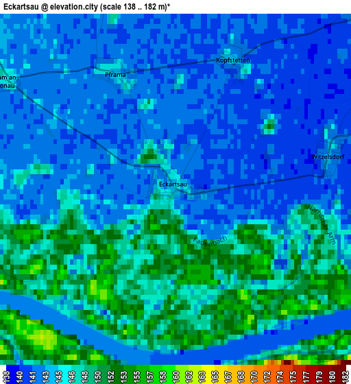
Below is the Elevation map of Eckartsau, which displays elevation range with different colors. Scale of the first map is from 138 to 182 m (453 to 597 ft) with average elevation of 145.2 meters (=476 ft) [note 1]
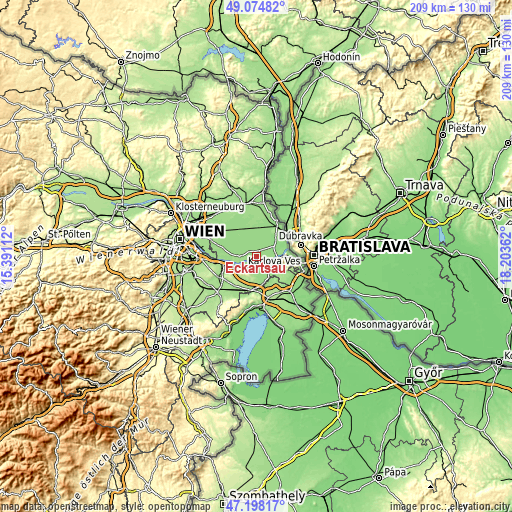
These maps also provides idea of topography and contour of this city, they are displayed at different zoom levels. More info about maps, scale and edge coordinates you can find below images.
| \ | Map #1 | Topo.Map |
| Scale [m] | 138..182 m | × |
| Scale [ft] | 453..597 ft | × |
| Average | 145.2 m = 476 ft | × |
| Width | 6.52 km = 4.1 mi | 208.7 km = 129.7 mi |
| Height | 6.52 km = 4.1 mi | 208.7 km = 129.7 mi |
| ↑Max Latitude | 48.174384° | 49.07482° |
| Latitude at center | 48.14507° | 48.14507° |
| ↓Min Latitude | 48.115739° | 47.19817° |
| ← Min Longitude | 16.753425° | 15.39112° |
| Longitude center | 16.79737° | 16.79737° |
| →Max Longitude | 16.841315° | 18.20362° |
Nearby cities:
Cities around Eckartsau sort by population:
• Lassee elevation 144 m
9.1 km,  11°
11°
• Orth an der Donau 150 m
7.2 km,  270°
270°
• Bad Deutsch-Altenburg 149 m
8.2 km,  98°
98°
• Petronell-Carnuntum 177 m
6.2 km,  125°
125°
• Höflein 181 m
8.8 km,  186°
186°
• Maria Ellend 185 m
9.8 km,  239°
239°
• Engelhartstetten 143 m
7.6 km,  57°
57°
• Haringsee 144 m
5.3 km,  352°
352°
• Rohrau 144 m
9.6 km,  155°
155°
• Scharndorf 188 m
5.7 km,  178°
178°
• Mannsdorf an der Donau 148 m
9.8 km, 274°
• Andlersdorf 147 m
10.6 km,  293°
293°
Multilingual:
 En español:
Eckartsau elevación 145 m.
 En France:
Eckartsau élévation 145 m.
 Auf Deutsch:
Eckartsau höhe über dem Meeresspiegel ist 145 m.

Sources and notes:
- [note 1] Map square and city borders are not equal. Map elevation data is calculated only from area inside that square.
- [src 1] Elevation data from geonames database provided with same terms of usage.
- [src 2] The elevation map of Eckartsau is generated using elevation data from NASA's 3 arcsec (90m) resolution SRTM data.
- [src 3] Base (background) map © OpenStreetMap contributors tiles are generated by Geofabrik and OpenTopoMap.
Copyright & License:
This Eckartsau Elevation Map is licensed under CC BY-SA. You may reuse any part from this page, if you give a proper credit by linking to this URL:
 More info on terms of use page.