Eichberg elevation
Eichberg (Styria, Politischer Bezirk Hartberg-Fürstenfeld), Austria elevation is 566 meters and Eichberg elevation in feet is 1857 ft above sea level [src 1]. Eichberg is a seat of a third-order administrative division (feature code) with elevation that is 57 meters (187 ft) bigger than average city elevation in Austria.
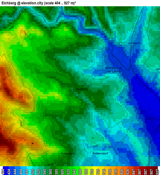
Below is the Elevation map of Eichberg, which displays elevation range with different colors. Scale of the first map is from 404 to 927 m (1325 to 3041 ft) with average elevation of 567.2 meters (=1861 ft) [note 1]
These maps also provides idea of topography and contour of this city, they are displayed at different zoom levels. More info about maps, scale and edge coordinates you can find below images.
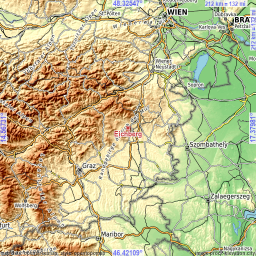
| \ | Map #1 | Topo.Map |
| Scale [m] | 404..927 m | × |
| Scale [ft] | 1325..3041 ft | × |
| Average | 567.2 m = 1861 ft | × |
| Width | 6.62 km = 4.1 mi | 211.7 km = 131.5 mi |
| Height | 6.62 km = 4.1 mi | 211.7 km = 131.5 mi |
| ↑Max Latitude | 47.411627° | 48.32547° |
| Latitude at center | 47.38188° | 47.38188° |
| ↓Min Latitude | 47.352116° | 46.42109° |
| ← Min Longitude | 15.929615° | 14.56731° |
| Longitude center | 15.97356° | 15.97356° |
| →Max Longitude | 16.017505° | 17.37981° |
Nearby cities:
Cities around Eichberg sort by population:
• Vorau elevation 650 m
7 km,  292°
292°
• Schachen bei Vorau 714 m
8.7 km,  268°
268°
• Grafendorf bei Hartberg 381 m
4.8 km,  164°
164°
• Rohrbach an der Lafnitz 433 m
2 km,  85°
85°
• Grafenschachen 419 m
7.2 km,  103°
103°
• Lafnitz 402 m
3.2 km,  118°
118°
• Neustift an der Lafnitz 452 m
4.8 km,  110°
110°
• Dechantskirchen 530 m
5 km,  39°
39°
• Rabenwald 658 m
5.9 km, 289°
• Sankt Lorenzen am Wechsel 738 m
6.8 km,  348°
348°
• Friedberg 552 m
8.1 km,  45°
45°
• Stambach 601 m
6.2 km,  209°
209°
Multilingual:
 En español:
Eichberg elevación 566 m.
 En France:
Eichberg élévation 566 m.
 Auf Deutsch:
Eichberg höhe über dem Meeresspiegel ist 566 m.

Sources and notes:
- [note 1] Map square and city borders are not equal. Map elevation data is calculated only from area inside that square.
- [src 1] Elevation data from geonames database provided with same terms of usage.
- [src 2] The elevation map of Eichberg is generated using elevation data from NASA's 3 arcsec (90m) resolution SRTM data.
- [src 3] Base (background) map © OpenStreetMap contributors tiles are generated by Geofabrik and OpenTopoMap.
Copyright & License:
This Eichberg Elevation Map is licensed under CC BY-SA. You may reuse any part from this page, if you give a proper credit by linking to this URL:
 More info on terms of use page.