Fieberbrunn elevation
Fieberbrunn (Tyrol, Politischer Bezirk Kitzbühel), Austria elevation is 777 meters and Fieberbrunn elevation in feet is 2549 ft above sea level [src 1]. Fieberbrunn is a seat of a third-order administrative division (feature code) with elevation that is 268 meters (879 ft) bigger than average city elevation in Austria.
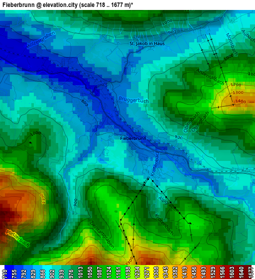
Below is the Elevation map of Fieberbrunn, which displays elevation range with different colors. Scale of the first map is from 718 to 1677 m (2356 to 5502 ft) with average elevation of 984.2 meters (=3229 ft) [note 1]
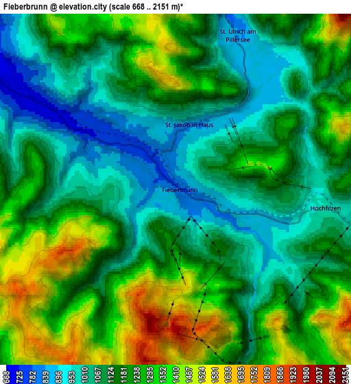
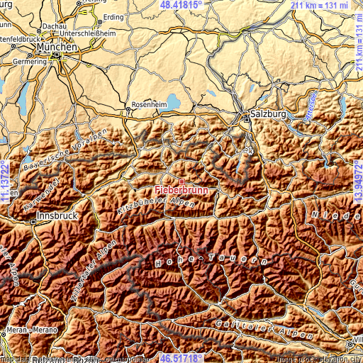
These maps also provides idea of topography and contour of this city, they are displayed at different zoom levels. More info about maps, scale and edge coordinates you can find below images.
| \ | Map #1 | Map #2 | Topo.Map |
| Scale [m] | 718..1677 m | 668..2151 m | × |
| Scale [ft] | 2356..5502 ft | 2192..7057 ft | × |
| Average | 984.2 m = 3229 ft | 1178.2 m = 3865 ft | × |
| Width | 6.61 km = 4.1 mi | 13.21 km = 8.2 mi | 211.4 km = 131.4 mi |
| Height | 6.61 km = 4.1 mi | 13.21 km = 8.2 mi | 211.4 km = 131.4 mi |
| ↑Max Latitude | 47.505954° | 47.535631° | 48.41815° |
| Latitude at center | 47.47626° | 47.47626° | 47.47626° |
| ↓Min Latitude | 47.446549° | 47.416822° | 46.51718° |
| ← Min Longitude | 12.499525° | 12.455579° | 11.13722° |
| Longitude center | 12.54347° | 12.54347° | 12.54347° |
| →Max Longitude | 12.587415° | 12.631361° | 13.94972° |
Nearby cities:
Cities around Fieberbrunn sort by population:
• Sankt Johann in Tirol elevation 659 m
10.4 km,  300°
300°
• Kitzbühel 751 m
11.9 km,  253°
253°
• Kirchdorf in Tirol 641 m
11.6 km,  320°
320°
• Oberndorf in Tirol 689 m
12.3 km,  282°
282°
• Waidring 796 m
12 km,  8°
8°
• Sankt Ulrich am Pillersee 845 m
6.1 km,  20°
20°
• Saalbach 1003 m
11.7 km,  143°
143°
• Jochberg 931 m
14.3 km,  221°
221°
• Hochfilzen 1000 m
5.6 km,  100°
100°
• Erpfendorf 808 m
13.2 km,  334°
334°
• Aurach 809 m
11.3 km,  230°
230°
• Hinterglemm 1063 m
11.7 km,  160°
160°
Multilingual:
 En español:
Fieberbrunn elevación 777 m.
 En France:
Fieberbrunn élévation 777 m.
 Auf Deutsch:
Fieberbrunn höhe über dem Meeresspiegel ist 777 m.

Sources and notes:
- [note 1] Map square and city borders are not equal. Map elevation data is calculated only from area inside that square.
- [src 1] Elevation data from geonames database provided with same terms of usage.
- [src 2] The elevation map of Fieberbrunn is generated using elevation data from NASA's 3 arcsec (90m) resolution SRTM data.
- [src 3] Base (background) map © OpenStreetMap contributors tiles are generated by Geofabrik and OpenTopoMap.
Copyright & License:
This Fieberbrunn Elevation Map is licensed under CC BY-SA. You may reuse any part from this page, if you give a proper credit by linking to this URL:
 More info on terms of use page.