Glojach elevation
Glojach (Styria, Politischer Bezirk Südoststeiermark), Austria elevation is 340 meters and Glojach elevation in feet is 1115 ft above sea level [src 1]. Glojach is a seat of a third-order administrative division (feature code) with elevation that is 169 meters (554 ft) smaller than average city elevation in Austria.
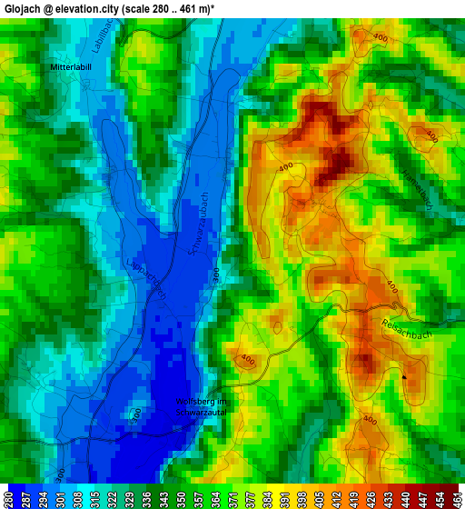
Below is the Elevation map of Glojach, which displays elevation range with different colors. Scale of the first map is from 280 to 461 m (919 to 1512 ft) with average elevation of 348.4 meters (=1143 ft) [note 1]
These maps also provides idea of topography and contour of this city, they are displayed at different zoom levels. More info about maps, scale and edge coordinates you can find below images.
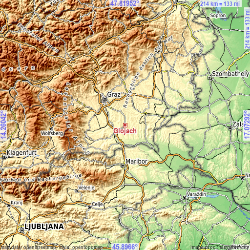
| \ | Map #1 | Topo.Map |
| Scale [m] | 280..461 m | × |
| Scale [ft] | 919..1512 ft | × |
| Average | 348.4 m = 1143 ft | × |
| Width | 6.68 km = 4.2 mi | 213.8 km = 132.8 mi |
| Height | 6.68 km = 4.2 mi | 213.8 km = 132.8 mi |
| ↑Max Latitude | 46.896707° | 47.81952° |
| Latitude at center | 46.86667° | 46.86667° |
| ↓Min Latitude | 46.836616° | 45.8966° |
| ← Min Longitude | 15.622725° | 14.26042° |
| Longitude center | 15.66667° | 15.66667° |
| →Max Longitude | 15.710615° | 17.07292° |
Nearby cities:
Cities around Glojach sort by population:
• Sankt Stefan im Rosental elevation 327 m
5.3 km,  38°
38°
• Kirchbach in Steiermark 333 m
7.2 km,  357°
357°
• Sankt Nikolai ob Draßling 282 m
6.5 km,  190°
190°
• Wolfsberg im Schwarzautal 289 m
2.6 km, 193°
• Sankt Georgen an der Stiefing 301 m
6.7 km,  276°
276°
• Jagerberg 377 m
5.6 km,  104°
104°
• Ragnitz 278 m
6.5 km,  239°
239°
• Schwarzau im Schwarzautal 297 m
1.4 km,  352°
352°
• Mitterlabill 312 m
3.4 km,  316°
316°
• Frannach 319 m
5.7 km,  334°
334°
• Breitenfeld am Tannenriegel 308 m
3.1 km,  233°
233°
• Hainsdorf im Schwarzautal 289 m
3.9 km,  209°
209°
Multilingual:
 En español:
Glojach elevación 340 m.
 En France:
Glojach élévation 340 m.


Sources and notes:
- [note 1] Map square and city borders are not equal. Map elevation data is calculated only from area inside that square.
- [src 1] Elevation data from geonames database provided with same terms of usage.
- [src 2] The elevation map of Glojach is generated using elevation data from NASA's 3 arcsec (90m) resolution SRTM data.
- [src 3] Base (background) map © OpenStreetMap contributors tiles are generated by Geofabrik and OpenTopoMap.
Copyright & License:
This Glojach Elevation Map is licensed under CC BY-SA. You may reuse any part from this page, if you give a proper credit by linking to this URL:
 More info on terms of use page.