Hart elevation
Hart (Upper Austria, Politischer Bezirk Linz-Land), Austria elevation is 285 meters and Hart elevation in feet is 935 ft above sea level [src 1]. Hart is a populated place (feature code) with elevation that is 224 meters (735 ft) smaller than average city elevation in Austria.
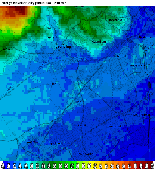
Below is the Elevation map of Hart, which displays elevation range with different colors. Scale of the first map is from 254 to 510 m (833 to 1673 ft) with average elevation of 288.7 meters (=947 ft) [note 1]
These maps also provides idea of topography and contour of this city, they are displayed at different zoom levels. More info about maps, scale and edge coordinates you can find below images.
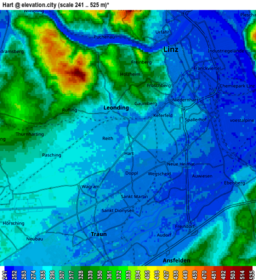
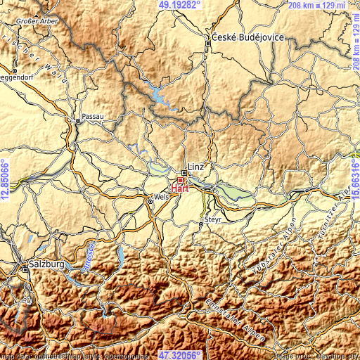
| \ | Map #1 | Map #2 | Topo.Map |
| Scale [m] | 254..510 m | 241..525 m | × |
| Scale [ft] | 833..1673 ft | 791..1722 ft | × |
| Average | 288.7 m = 947 ft | 293.9 m = 964 ft | × |
| Width | 6.51 km = 4 mi | 13.01 km = 8.1 mi | 208.2 km = 129.4 mi |
| Height | 6.51 km = 4 mi | 13.01 km = 8.1 mi | 208.2 km = 129.4 mi |
| ↑Max Latitude | 48.294505° | 48.323734° | 49.19282° |
| Latitude at center | 48.26526° | 48.26526° | 48.26526° |
| ↓Min Latitude | 48.235998° | 48.206719° | 47.32056° |
| ← Min Longitude | 14.212965° | 14.169019° | 12.85066° |
| Longitude center | 14.25691° | 14.25691° | 14.25691° |
| →Max Longitude | 14.300855° | 14.344801° | 15.66316° |
Nearby cities:
Cities around Hart sort by population:
• Sankt Martin elevation 263 m
3.9 km,  168°
168°
• Haag 280 m
1.1 km,  55°
55°
• Leonding 289 m
1.6 km,  350°
350°
• Langholzfeld 272 m
2.6 km,  195°
195°
• Doppl 273 m
1.9 km,  186°
186°
• Sankt Dionysen 268 m
4.5 km,  181°
181°
• Pasching 294 m
4 km,  260°
260°
• Gaumberg 324 m
2 km,  27°
27°
• Berg 368 m
3.1 km, 347°
• Rufling 331 m
3.3 km,  296°
296°
• Bergham 306 m
2.6 km,  314°
314°
• Wagram 274 m
3.6 km,  213°
213°
Multilingual:
 En español:
Hart elevación 285 m.
 En France:
Hart élévation 285 m.


Sources and notes:
- [note 1] Map square and city borders are not equal. Map elevation data is calculated only from area inside that square.
- [src 1] Elevation data from geonames database provided with same terms of usage.
- [src 2] The elevation map of Hart is generated using elevation data from NASA's 3 arcsec (90m) resolution SRTM data.
- [src 3] Base (background) map © OpenStreetMap contributors tiles are generated by Geofabrik and OpenTopoMap.
Copyright & License:
This Hart Elevation Map is licensed under CC BY-SA. You may reuse any part from this page, if you give a proper credit by linking to this URL:
 More info on terms of use page.