Himmelreich elevation
Himmelreich (Salzburg, Politischer Bezirk Salzburg-Umgebung), Austria elevation is 437 meters and Himmelreich elevation in feet is 1434 ft above sea level [src 1]. Himmelreich is a populated place (feature code) with elevation that is 72 meters (236 ft) smaller than average city elevation in Austria.
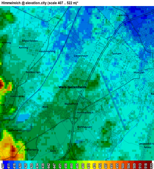
Below is the Elevation map of Himmelreich, which displays elevation range with different colors. Scale of the first map is from 407 to 522 m (1335 to 1713 ft) with average elevation of 431.8 meters (=1417 ft) [note 1]
These maps also provides idea of topography and contour of this city, they are displayed at different zoom levels. More info about maps, scale and edge coordinates you can find below images.
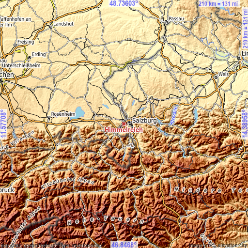
| \ | Map #1 | Topo.Map |
| Scale [m] | 407..522 m | × |
| Scale [ft] | 1335..1713 ft | × |
| Average | 431.8 m = 1417 ft | × |
| Width | 6.56 km = 4.1 mi | 210.1 km = 130.5 mi |
| Height | 6.56 km = 4.1 mi | 210 km = 130.5 mi |
| ↑Max Latitude | 47.829511° | 48.73603° |
| Latitude at center | 47.8° | 47.8° |
| ↓Min Latitude | 47.770473° | 46.8468° |
| ← Min Longitude | 12.939385° | 11.57708° |
| Longitude center | 12.98333° | 12.98333° |
| →Max Longitude | 13.027275° | 14.38958° |
Nearby cities:
Cities around Himmelreich sort by population:
• Salzburg elevation 435 m
4.5 km,  90°
90°
• Grödig 448 m
8 km,  149°
149°
• Wals 439 m
2.2 km,  213°
213°
• Siezenheim 427 m
1.8 km,  17°
17°
• Bergheim 436 m
5.3 km,  45°
45°
• Elsbethen 437 m
8.3 km,  118°
118°
• Glanegg 440 m
5.7 km,  167°
167°
• Viehhausen 435 m
1.9 km,  180°
180°
• Glasenbach 443 m
8.3 km, 116°
• Lengfelden 442 m
7.5 km,  41°
41°
• Walserfeld 438 m
0.9 km,  196°
196°
• Lehen 429 m
8.3 km, 17°
Multilingual:
 En español:
Himmelreich elevación 437 m.
 En France:
Himmelreich élévation 437 m.
 Auf Deutsch:
Himmelreich höhe über dem Meeresspiegel ist 437 m.

Sources and notes:
- [note 1] Map square and city borders are not equal. Map elevation data is calculated only from area inside that square.
- [src 1] Elevation data from geonames database provided with same terms of usage.
- [src 2] The elevation map of Himmelreich is generated using elevation data from NASA's 3 arcsec (90m) resolution SRTM data.
- [src 3] Base (background) map © OpenStreetMap contributors tiles are generated by Geofabrik and OpenTopoMap.
Copyright & License:
This Himmelreich Elevation Map is licensed under CC BY-SA. You may reuse any part from this page, if you give a proper credit by linking to this URL:
 More info on terms of use page.