Hofstetten elevation
Hofstetten (Lower Austria, Politischer Bezirk Sankt Pölten), Austria elevation is 314 meters and Hofstetten elevation in feet is 1030 ft above sea level [src 1]. Hofstetten is a populated place (feature code) with elevation that is 195 meters (640 ft) smaller than average city elevation in Austria.
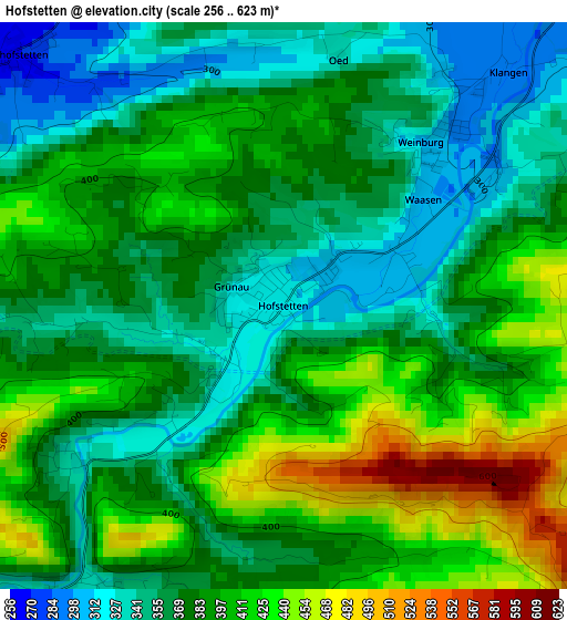
Below is the Elevation map of Hofstetten, which displays elevation range with different colors. Scale of the first map is from 256 to 623 m (840 to 2044 ft) with average elevation of 383.2 meters (=1257 ft) [note 1]
These maps also provides idea of topography and contour of this city, they are displayed at different zoom levels. More info about maps, scale and edge coordinates you can find below images.
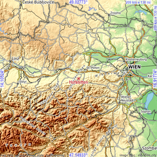
| \ | Map #1 | Topo.Map |
| Scale [m] | 256..623 m | × |
| Scale [ft] | 840..2044 ft | × |
| Average | 383.2 m = 1257 ft | × |
| Width | 6.53 km = 4.1 mi | 208.9 km = 129.8 mi |
| Height | 6.53 km = 4.1 mi | 208.8 km = 129.7 mi |
| ↑Max Latitude | 48.126451° | 49.02773° |
| Latitude at center | 48.09711° | 48.09711° |
| ↓Min Latitude | 48.067752° | 47.14933° |
| ← Min Longitude | 15.467545° | 14.10524° |
| Longitude center | 15.51149° | 15.51149° |
| →Max Longitude | 15.555435° | 16.91774° |
Nearby cities:
Cities around Hofstetten sort by population:
• Wilhelmsburg elevation 320 m
7 km,  82°
82°
• Traisen 396 m
9.7 km,  137°
137°
• Ober-Grafendorf 279 m
6.4 km,  22°
22°
• Markersdorf an der Pielach 254 m
9.6 km,  354°
354°
• Kilb 299 m
7.7 km,  273°
273°
• Eggendorf 306 m
8.9 km,  64°
64°
• Rabenstein an der Pielach 343 m
4.8 km,  222°
222°
• Weinburg 306 m
2.4 km,  41°
41°
• Hürm 275 m
9.8 km,  311°
311°
• Bischofstetten 265 m
4.2 km, 311°
• Eschenau 394 m
6.8 km, 142°
• Sankt Margarethen an der Sierning 253 m
7.1 km, 347°
Multilingual:
 En español:
Hofstetten elevación 314 m.
 En France:
Hofstetten élévation 314 m.
 Auf Deutsch:
Hofstetten höhe über dem Meeresspiegel ist 314 m.

Sources and notes:
- [note 1] Map square and city borders are not equal. Map elevation data is calculated only from area inside that square.
- [src 1] Elevation data from geonames database provided with same terms of usage.
- [src 2] The elevation map of Hofstetten is generated using elevation data from NASA's 3 arcsec (90m) resolution SRTM data.
- [src 3] Base (background) map © OpenStreetMap contributors tiles are generated by Geofabrik and OpenTopoMap.
Copyright & License:
This Hofstetten Elevation Map is licensed under CC BY-SA. You may reuse any part from this page, if you give a proper credit by linking to this URL:
 More info on terms of use page.