Horn elevation
Horn (Lower Austria, Politischer Bezirk Horn), Austria elevation is 307 meters and Horn elevation in feet is 1007 ft above sea level [src 1]. Horn is a seat of a third-order administrative division (feature code) with elevation that is 202 meters (663 ft) smaller than average city elevation in Austria.
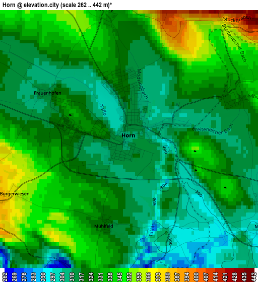
Below is the Elevation map of Horn, which displays elevation range with different colors. Scale of the first map is from 262 to 442 m (860 to 1450 ft) with average elevation of 325.3 meters (=1067 ft) [note 1]
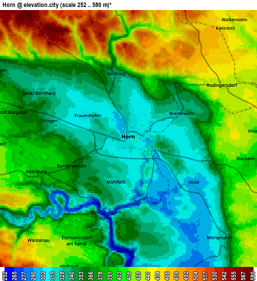
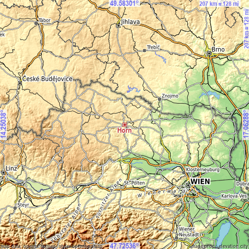
These maps also provides idea of topography and contour of this city, they are displayed at different zoom levels. More info about maps, scale and edge coordinates you can find below images.
| \ | Map #1 | Map #2 | Topo.Map |
| Scale [m] | 262..442 m | 252..580 m | × |
| Scale [ft] | 860..1450 ft | 827..1903 ft | × |
| Average | 325.3 m = 1067 ft | 384.4 m = 1261 ft | × |
| Width | 6.45 km = 4 mi | 12.91 km = 8 mi | 206.6 km = 128.4 mi |
| Height | 6.45 km = 4 mi | 12.91 km = 8 mi | 206.5 km = 128.3 mi |
| ↑Max Latitude | 48.691757° | 48.720757° | 49.58301° |
| Latitude at center | 48.66274° | 48.66274° | 48.66274° |
| ↓Min Latitude | 48.633706° | 48.604656° | 47.72536° |
| ← Min Longitude | 15.612685° | 15.568739° | 14.25038° |
| Longitude center | 15.65663° | 15.65663° | 15.65663° |
| →Max Longitude | 15.700575° | 15.744521° | 17.06288° |
Nearby cities:
Cities around Horn sort by population:
• Eggenburg elevation 339 m
12.2 km,  102°
102°
• Gars am Kamp 246 m
8.2 km,  181°
181°
• Pulkau 260 m
15.7 km,  72°
72°
• Röschitz 324 m
12 km, 100°
• Sigmundsherberg 435 m
7.2 km, 71°
• Geras 459 m
15 km,  4°
4°
• Altenburg 389 m
5 km,  250°
250°
• Sankt Leonhard am Hornerwald 523 m
11.4 km,  232°
232°
• Brunn an der Wild 443 m
10.6 km,  289°
289°
• Japons 510 m
15.8 km,  335°
335°
• Pernegg 507 m
8.4 km, 339°
• Röhrenbach 465 m
11.6 km,  262°
262°
Multilingual:
 En español:
Horn elevación 307 m.
 En France:
Horn élévation 307 m.


Sources and notes:
- [note 1] Map square and city borders are not equal. Map elevation data is calculated only from area inside that square.
- [src 1] Elevation data from geonames database provided with same terms of usage.
- [src 2] The elevation map of Horn is generated using elevation data from NASA's 3 arcsec (90m) resolution SRTM data.
- [src 3] Base (background) map © OpenStreetMap contributors tiles are generated by Geofabrik and OpenTopoMap.
Copyright & License:
This Horn Elevation Map is licensed under CC BY-SA. You may reuse any part from this page, if you give a proper credit by linking to this URL:
 More info on terms of use page.