Klöch elevation
Klöch (Styria, Politischer Bezirk Südoststeiermark), Austria elevation is 304 meters and Klöch elevation in feet is 997 ft above sea level [src 1]. Klöch is a seat of a third-order administrative division (feature code) with elevation that is 205 meters (673 ft) smaller than average city elevation in Austria.
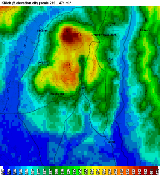
Below is the Elevation map of Klöch, which displays elevation range with different colors. Scale of the first map is from 219 to 471 m (719 to 1545 ft) with average elevation of 282.8 meters (=928 ft) [note 1]
These maps also provides idea of topography and contour of this city, they are displayed at different zoom levels. More info about maps, scale and edge coordinates you can find below images.
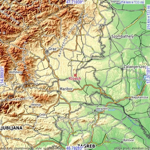
| \ | Map #1 | Topo.Map |
| Scale [m] | 219..471 m | × |
| Scale [ft] | 719..1545 ft | × |
| Average | 282.8 m = 928 ft | × |
| Width | 6.69 km = 4.2 mi | 214.2 km = 133.1 mi |
| Height | 6.69 km = 4.2 mi | 214.2 km = 133.1 mi |
| ↑Max Latitude | 46.794814° | 47.71939° |
| Latitude at center | 46.76472° | 46.76472° |
| ↓Min Latitude | 46.734609° | 45.79283° |
| ← Min Longitude | 15.921615° | 14.55931° |
| Longitude center | 15.96556° | 15.96556° |
| →Max Longitude | 16.009505° | 17.37181° |
Nearby cities:
Cities around Klöch sort by population:
• Bad Radkersburg elevation 212 m
8.7 km,  168°
168°
• Bairisch Kölldorf 385 m
11.6 km,  347°
347°
• Ratschendorf 243 m
11.7 km,  257°
257°
• Halbenrain 222 m
5 km,  196°
196°
• Merkendorf 266 m
11.3 km,  335°
335°
• Deutsch Goritz 244 m
10.5 km, 261°
• Hof bei Straden 327 m
4.6 km,  327°
327°
• Tieschen 247 m
3 km,  323°
323°
• Straden 336 m
8.9 km,  303°
303°
• Stainz bei Straden 251 m
8.7 km, 319°
• Krusdorf 272 m
11.5 km, 316°
• Sankt Anna am Aigen 365 m
7.4 km,  3°
3°
Multilingual:
 En español:
Klöch elevación 304 m.
 En France:
Klöch élévation 304 m.


Sources and notes:
- [note 1] Map square and city borders are not equal. Map elevation data is calculated only from area inside that square.
- [src 1] Elevation data from geonames database provided with same terms of usage.
- [src 2] The elevation map of Klöch is generated using elevation data from NASA's 3 arcsec (90m) resolution SRTM data.
- [src 3] Base (background) map © OpenStreetMap contributors tiles are generated by Geofabrik and OpenTopoMap.
Copyright & License:
This Klöch Elevation Map is licensed under CC BY-SA. You may reuse any part from this page, if you give a proper credit by linking to this URL:
 More info on terms of use page.