Kraubath an der Mur elevation
Kraubath an der Mur (Styria, Politischer Bezirk Leoben), Austria elevation is 608 meters and Kraubath an der Mur elevation in feet is 1995 ft above sea level [src 1]. Kraubath an der Mur is a seat of a third-order administrative division (feature code) with elevation that is 99 meters (325 ft) bigger than average city elevation in Austria.
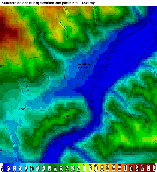
Below is the Elevation map of Kraubath an der Mur, which displays elevation range with different colors. Scale of the first map is from 571 to 1381 m (1873 to 4531 ft) with average elevation of 785.5 meters (=2577 ft) [note 1]
These maps also provides idea of topography and contour of this city, they are displayed at different zoom levels. More info about maps, scale and edge coordinates you can find below images.
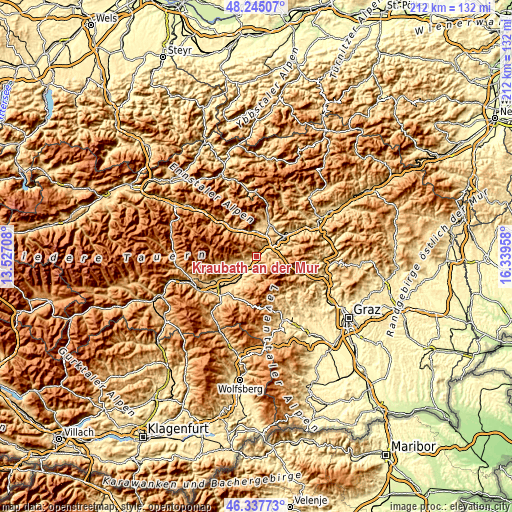
| \ | Map #1 | Topo.Map |
| Scale [m] | 571..1381 m | × |
| Scale [ft] | 1873..4531 ft | × |
| Average | 785.5 m = 2577 ft | × |
| Width | 6.63 km = 4.1 mi | 212.1 km = 131.8 mi |
| Height | 6.63 km = 4.1 mi | 212.1 km = 131.8 mi |
| ↑Max Latitude | 47.329794° | 48.24507° |
| Latitude at center | 47.3° | 47.3° |
| ↓Min Latitude | 47.27019° | 46.33773° |
| ← Min Longitude | 14.889385° | 13.52708° |
| Longitude center | 14.93333° | 14.93333° |
| →Max Longitude | 14.977275° | 16.33958° |
Nearby cities:
Cities around Kraubath an der Mur sort by population:
• Liesingtal elevation 592 m
7.9 km,  49°
49°
• Sankt Peter-Freienstein 859 m
11.2 km,  34°
34°
• Sankt Stefan ob Leoben 590 m
3.9 km,  61°
61°
• Sankt Michael in Obersteiermark 581 m
7.7 km, 56°
• Kammern im Liesingtal 666 m
10.5 km,  347°
347°
• Sankt Margarethen bei Knittelfeld 833 m
10.5 km,  208°
208°
• Kobenz 640 m
8.4 km,  228°
228°
• Feistritz bei Knittelfeld 638 m
4.7 km,  220°
220°
• Sankt Lorenzen bei Knittelfeld 603 m
6.2 km, 207°
• Traboch 619 m
9.5 km, 25°
• Sankt Marein bei Knittelfeld 705 m
6.2 km,  242°
242°
• Rachau 796 m
9.6 km,  195°
195°
Multilingual:
 En español:
Kraubath an der Mur elevación 608 m.
 En France:
Kraubath an der Mur élévation 608 m.
 Auf Deutsch:
Kraubath an der Mur höhe über dem Meeresspiegel ist 608 m.
 На русском:
Kraubath an der Mur высота над уровнем моря 608 м
Sources and notes:
- [note 1] Map square and city borders are not equal. Map elevation data is calculated only from area inside that square.
- [src 1] Elevation data from geonames database provided with same terms of usage.
- [src 2] The elevation map of Kraubath an der Mur is generated using elevation data from NASA's 3 arcsec (90m) resolution SRTM data.
- [src 3] Base (background) map © OpenStreetMap contributors tiles are generated by Geofabrik and OpenTopoMap.
Copyright & License:
This Kraubath an der Mur Elevation Map is licensed under CC BY-SA. You may reuse any part from this page, if you give a proper credit by linking to this URL:
 More info on terms of use page.