Leitendorf elevation
Leitendorf (Styria, Politischer Bezirk Leoben), Austria elevation is 581 meters and Leitendorf elevation in feet is 1906 ft above sea level [src 1]. Leitendorf is a section of populated place (feature code) with elevation that is 72 meters (236 ft) bigger than average city elevation in Austria.
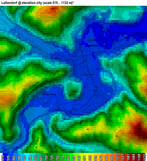
Below is the Elevation map of Leitendorf, which displays elevation range with different colors. Scale of the first map is from 515 to 1132 m (1690 to 3714 ft) with average elevation of 676.1 meters (=2218 ft) [note 1]
These maps also provides idea of topography and contour of this city, they are displayed at different zoom levels. More info about maps, scale and edge coordinates you can find below images.
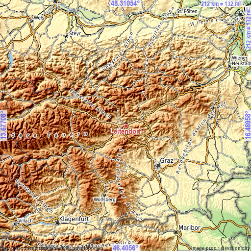
| \ | Map #1 | Topo.Map |
| Scale [m] | 515..1132 m | × |
| Scale [ft] | 1690..3714 ft | × |
| Average | 676.1 m = 2218 ft | × |
| Width | 6.62 km = 4.1 mi | 211.8 km = 131.6 mi |
| Height | 6.62 km = 4.1 mi | 211.8 km = 131.6 mi |
| ↑Max Latitude | 47.396426° | 48.31054° |
| Latitude at center | 47.36667° | 47.36667° |
| ↓Min Latitude | 47.336897° | 46.4056° |
| ← Min Longitude | 15.039385° | 13.67708° |
| Longitude center | 15.08333° | 15.08333° |
| →Max Longitude | 15.127275° | 16.48958° |
Nearby cities:
Cities around Leitendorf sort by population:
• Leoben elevation 543 m
1.3 km,  29°
29°
• Trofaiach 660 m
8.7 km,  318°
318°
• Judendorf 693 m
3.9 km,  18°
18°
• Göss 605 m
1.5 km,  124°
124°
• Donawitz 763 m
1.3 km,  270°
270°
• Niklasdorf 622 m
5.4 km,  69°
69°
• Liesingtal 592 m
5.7 km,  246°
246°
• Proleb 579 m
5.3 km,  45°
45°
• Sankt Peter-Freienstein 859 m
5.4 km,  290°
290°
• Hinterberg 557 m
1.2 km,  237°
237°
• Sankt Michael in Obersteiermark 581 m
5.9 km, 237°
• Traboch 619 m
7.4 km,  278°
278°
Multilingual:
 En español:
Leitendorf elevación 581 m.
 En France:
Leitendorf élévation 581 m.
 Auf Deutsch:
Leitendorf höhe über dem Meeresspiegel ist 581 m.

Sources and notes:
- [note 1] Map square and city borders are not equal. Map elevation data is calculated only from area inside that square.
- [src 1] Elevation data from geonames database provided with same terms of usage.
- [src 2] The elevation map of Leitendorf is generated using elevation data from NASA's 3 arcsec (90m) resolution SRTM data.
- [src 3] Base (background) map © OpenStreetMap contributors tiles are generated by Geofabrik and OpenTopoMap.
Copyright & License:
This Leitendorf Elevation Map is licensed under CC BY-SA. You may reuse any part from this page, if you give a proper credit by linking to this URL:
 More info on terms of use page.