Mank elevation
Mank (Lower Austria, Politischer Bezirk Melk), Austria elevation is 296 meters and Mank elevation in feet is 971 ft above sea level [src 1]. Mank is a seat of a third-order administrative division (feature code) with elevation that is 213 meters (699 ft) smaller than average city elevation in Austria.
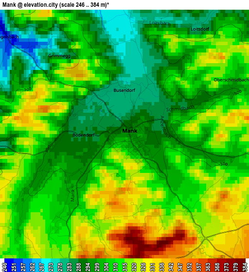
Below is the Elevation map of Mank, which displays elevation range with different colors. Scale of the first map is from 246 to 384 m (807 to 1260 ft) with average elevation of 307.8 meters (=1010 ft) [note 1]
These maps also provides idea of topography and contour of this city, they are displayed at different zoom levels. More info about maps, scale and edge coordinates you can find below images.
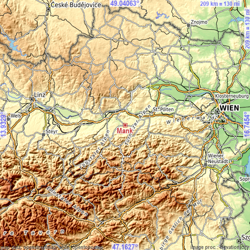
| \ | Map #1 | Topo.Map |
| Scale [m] | 246..384 m | × |
| Scale [ft] | 807..1260 ft | × |
| Average | 307.8 m = 1010 ft | × |
| Width | 6.53 km = 4.1 mi | 208.8 km = 129.7 mi |
| Height | 6.53 km = 4.1 mi | 208.8 km = 129.7 mi |
| ↑Max Latitude | 48.139574° | 49.04063° |
| Latitude at center | 48.11024° | 48.11024° |
| ↓Min Latitude | 48.080889° | 47.1627° |
| ← Min Longitude | 15.295205° | 13.9329° |
| Longitude center | 15.33915° | 15.33915° |
| →Max Longitude | 15.383095° | 16.7454° |
Nearby cities:
Cities around Mank sort by population:
• Loosdorf elevation 226 m
11 km,  24°
24°
• Sankt Leonhard am Forst 244 m
5.4 km,  311°
311°
• Kirchberg an der Pielach 371 m
11.4 km,  144°
144°
• Kilb 299 m
5.3 km,  101°
101°
• Ruprechtshofen 241 m
5.5 km,  302°
302°
• Rabenstein an der Pielach 343 m
10.8 km,  117°
117°
• Hürm 275 m
7.5 km,  46°
46°
• Oberndorf an der Melk 321 m
10 km,  238°
238°
• Bischofstetten 265 m
9.7 km,  82°
82°
• Kirnberg an der Mank 329 m
4.4 km,  196°
196°
• Sankt Margarethen an der Sierning 253 m
12.5 km,  64°
64°
• Sankt Georgen an der Leys 380 m
12.1 km,  223°
223°
Multilingual:
 En español:
Mank elevación 296 m.
 En France:
Mank élévation 296 m.


Sources and notes:
- [note 1] Map square and city borders are not equal. Map elevation data is calculated only from area inside that square.
- [src 1] Elevation data from geonames database provided with same terms of usage.
- [src 2] The elevation map of Mank is generated using elevation data from NASA's 3 arcsec (90m) resolution SRTM data.
- [src 3] Base (background) map © OpenStreetMap contributors tiles are generated by Geofabrik and OpenTopoMap.
Copyright & License:
This Mank Elevation Map is licensed under CC BY-SA. You may reuse any part from this page, if you give a proper credit by linking to this URL:
 More info on terms of use page.