Mattighofen elevation
Mattighofen (Upper Austria, Politischer Bezirk Braunau am Inn), Austria elevation is 445 meters and Mattighofen elevation in feet is 1460 ft above sea level [src 1]. Mattighofen is a seat of a third-order administrative division (feature code) with elevation that is 64 meters (210 ft) smaller than average city elevation in Austria.
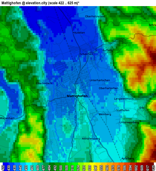
Below is the Elevation map of Mattighofen, which displays elevation range with different colors. Scale of the first map is from 422 to 625 m (1385 to 2051 ft) with average elevation of 474.8 meters (=1558 ft) [note 1]
These maps also provides idea of topography and contour of this city, they are displayed at different zoom levels. More info about maps, scale and edge coordinates you can find below images.
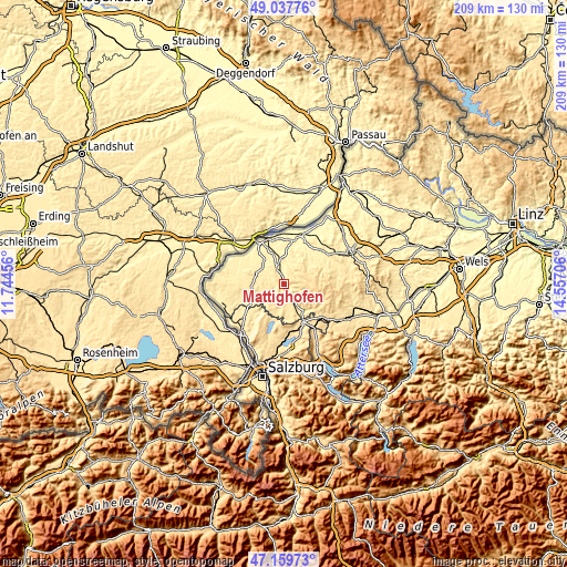
| \ | Map #1 | Map #2 | Topo.Map |
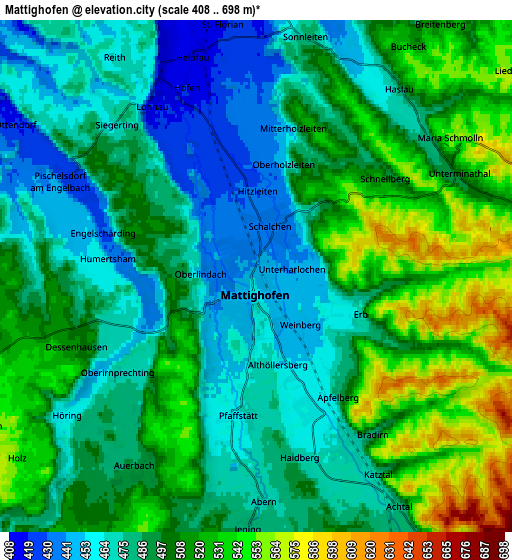
| Scale [m] | 422..625 m | 408..698 m | × |
| Scale [ft] | 1385..2051 ft | 1339..2290 ft | × |
| Average | 474.8 m = 1558 ft | 496.9 m = 1630 ft | × |
| Width | 6.53 km = 4.1 mi | 13.05 km = 8.1 mi | 208.8 km = 129.7 mi |
| Height | 6.53 km = 4.1 mi | 13.05 km = 8.1 mi | 208.8 km = 129.7 mi |
| ↑Max Latitude | 48.136656° | 48.165974° | 49.03776° |
| Latitude at center | 48.10732° | 48.10732° | 48.10732° |
| ↓Min Latitude | 48.077968° | 48.048599° | 47.15973° |
| ← Min Longitude | 13.106865° | 13.062919° | 11.74456° |
| Longitude center | 13.15081° | 13.15081° | 13.15081° |
| →Max Longitude | 13.194755° | 13.238701° | 14.55706° |
Nearby cities:
Cities around Mattighofen sort by population:
• Mauerkirchen elevation 399 m
9.5 km,  352°
352°
• Schalchen 437 m
1.4 km,  19°
19°
• Munderfing 467 m
4.7 km,  150°
150°
• Uttendorf 393 m
6.1 km,  339°
339°
• Berndorf bei Salzburg 550 m
14.1 km,  208°
208°
• Moosdorf 475 m
13.9 km,  240°
240°
• Perwang am Grabensee 524 m
12.2 km,  204°
204°
• Maria Schmolln 558 m
6.2 km,  56°
56°
• Handenberg 496 m
11 km,  285°
285°
• Sankt Georgen am Fillmannsbach 449 m
10.8 km,  280°
280°
• Palting 514 m
10.4 km,  189°
189°
• Wagnergraben 473 m
13.5 km,  224°
224°
Multilingual:
 En español:
Mattighofen elevación 445 m.
 En France:
Mattighofen élévation 445 m.
 Auf Deutsch:
Mattighofen höhe über dem Meeresspiegel ist 445 m.

Sources and notes:
- [note 1] Map square and city borders are not equal. Map elevation data is calculated only from area inside that square.
- [src 1] Elevation data from geonames database provided with same terms of usage.
- [src 2] The elevation map of Mattighofen is generated using elevation data from NASA's 3 arcsec (90m) resolution SRTM data.
- [src 3] Base (background) map © OpenStreetMap contributors tiles are generated by Geofabrik and OpenTopoMap.
Copyright & License:
This Mattighofen Elevation Map is licensed under CC BY-SA. You may reuse any part from this page, if you give a proper credit by linking to this URL:
 More info on terms of use page.