Mehrnbach elevation
Mehrnbach (Upper Austria, Politischer Bezirk Ried im Innkreis), Austria elevation is 445 meters and Mehrnbach elevation in feet is 1460 ft above sea level [src 1]. Mehrnbach is a populated place (feature code) with elevation that is 64 meters (210 ft) smaller than average city elevation in Austria.
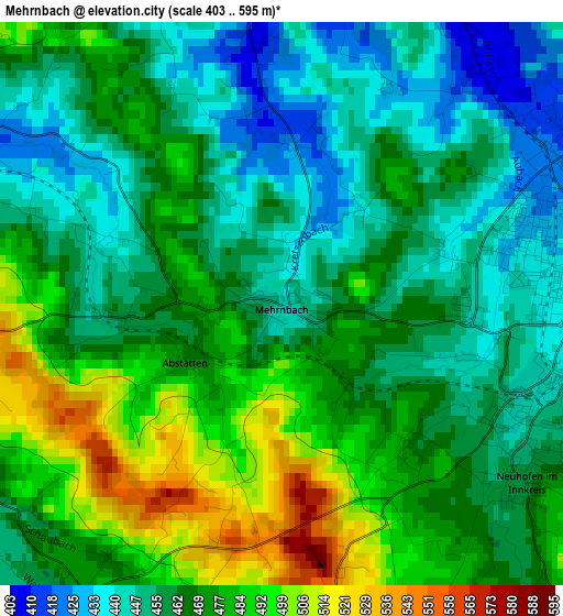
Below is the Elevation map of Mehrnbach, which displays elevation range with different colors. Scale of the first map is from 403 to 595 m (1322 to 1952 ft) with average elevation of 466.5 meters (=1531 ft) [note 1]
These maps also provides idea of topography and contour of this city, they are displayed at different zoom levels. More info about maps, scale and edge coordinates you can find below images.
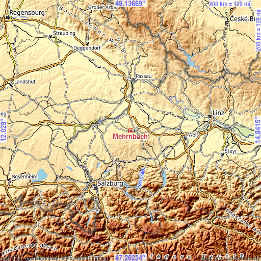
| \ | Map #1 | Topo.Map |
| Scale [m] | 403..595 m | × |
| Scale [ft] | 1322..1952 ft | × |
| Average | 466.5 m = 1531 ft | × |
| Width | 6.51 km = 4 mi | 208.4 km = 129.5 mi |
| Height | 6.51 km = 4 mi | 208.4 km = 129.5 mi |
| ↑Max Latitude | 48.237368° | 49.13669° |
| Latitude at center | 48.20809° | 48.20809° |
| ↓Min Latitude | 48.178795° | 47.26234° |
| ← Min Longitude | 13.391305° | 12.029° |
| Longitude center | 13.43525° | 13.43525° |
| →Max Longitude | 13.479195° | 14.8415° |
Nearby cities:
Cities around Mehrnbach sort by population:
• Ried im Innkreis elevation 435 m
4 km,  84°
84°
• Diesseits 371 m
9.3 km,  0°
0°
• Aurolzmünster 405 m
4.7 km,  18°
18°
• Waldzell 511 m
8.1 km,  184°
184°
• Utzenaich 399 m
7.8 km,  14°
14°
• Eberschwang 523 m
11.1 km,  122°
122°
• Schildorn 524 m
7.2 km,  163°
163°
• Pattigham 509 m
6.9 km,  148°
148°
• Pramet 508 m
8.2 km, 151°
• Weilbach 382 m
9 km,  328°
328°
• Wippenham 425 m
4.5 km,  291°
291°
• Sankt Martin im Innkreis 371 m
9.5 km, 1°
Multilingual:
 En español:
Mehrnbach elevación 445 m.
 En France:
Mehrnbach élévation 445 m.
 Auf Deutsch:
Mehrnbach höhe über dem Meeresspiegel ist 445 m.

Sources and notes:
- [note 1] Map square and city borders are not equal. Map elevation data is calculated only from area inside that square.
- [src 1] Elevation data from geonames database provided with same terms of usage.
- [src 2] The elevation map of Mehrnbach is generated using elevation data from NASA's 3 arcsec (90m) resolution SRTM data.
- [src 3] Base (background) map © OpenStreetMap contributors tiles are generated by Geofabrik and OpenTopoMap.
Copyright & License:
This Mehrnbach Elevation Map is licensed under CC BY-SA. You may reuse any part from this page, if you give a proper credit by linking to this URL:
 More info on terms of use page.