Münster elevation
Münster (Tyrol, Politischer Bezirk Kufstein), Austria elevation is 536 meters and Münster elevation in feet is 1759 ft above sea level [src 1]. Münster is a seat of a third-order administrative division (feature code) with elevation that is 27 meters (89 ft) bigger than average city elevation in Austria.
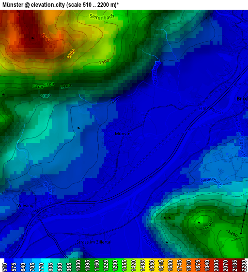
Below is the Elevation map of Münster, which displays elevation range with different colors. Scale of the first map is from 510 to 2200 m (1673 to 7218 ft) with average elevation of 809.1 meters (=2655 ft) [note 1]
These maps also provides idea of topography and contour of this city, they are displayed at different zoom levels. More info about maps, scale and edge coordinates you can find below images.
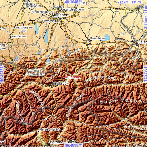
| \ | Map #1 | Topo.Map |
| Scale [m] | 510..2200 m | × |
| Scale [ft] | 1673..7218 ft | × |
| Average | 809.1 m = 2655 ft | × |
| Width | 6.61 km = 4.1 mi | 211.6 km = 131.5 mi |
| Height | 6.61 km = 4.1 mi | 211.6 km = 131.5 mi |
| ↑Max Latitude | 47.451365° | 48.36452° |
| Latitude at center | 47.42164° | 47.42164° |
| ↓Min Latitude | 47.391898° | 46.46157° |
| ← Min Longitude | 11.789615° | 10.42731° |
| Longitude center | 11.83356° | 11.83356° |
| →Max Longitude | 11.877505° | 13.23981° |
Nearby cities:
Cities around Münster sort by population:
• Jenbach elevation 564 m
5.7 km,  234°
234°
• Voldöpp 519 m
4.5 km,  55°
55°
• Reith im Alpbachtal 636 m
3.4 km,  98°
98°
• Brixlegg 534 m
3.4 km,  75°
75°
• Mariatal 525 m
4.1 km,  44°
44°
• Schlitters 532 m
4.6 km,  175°
175°
• Wiesing 566 m
3.3 km,  235°
235°
• Strass im Zillertal 524 m
3.1 km,  199°
199°
• Bruck am Ziller 567 m
3.8 km,  159°
159°
• Rattenberg 524 m
5 km,  66°
66°
• Eben am Achensee 959 m
5.5 km,  260°
260°
• Kramsach 532 m
4 km,  52°
52°
Multilingual:
 En español:
Münster elevación 536 m.
 En France:
Münster élévation 536 m.


Sources and notes:
- [note 1] Map square and city borders are not equal. Map elevation data is calculated only from area inside that square.
- [src 1] Elevation data from geonames database provided with same terms of usage.
- [src 2] The elevation map of Münster is generated using elevation data from NASA's 3 arcsec (90m) resolution SRTM data.
- [src 3] Base (background) map © OpenStreetMap contributors tiles are generated by Geofabrik and OpenTopoMap.
Copyright & License:
This Münster Elevation Map is licensed under CC BY-SA. You may reuse any part from this page, if you give a proper credit by linking to this URL:
 More info on terms of use page.