Mureck elevation
Mureck (Styria, Politischer Bezirk Südoststeiermark), Austria elevation is 237 meters and Mureck elevation in feet is 778 ft above sea level [src 1]. Mureck is a seat of a third-order administrative division (feature code) with elevation that is 272 meters (892 ft) smaller than average city elevation in Austria.
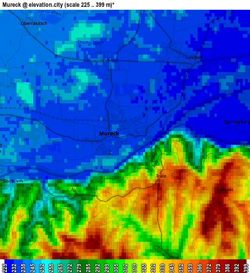
Below is the Elevation map of Mureck, which displays elevation range with different colors. Scale of the first map is from 225 to 399 m (738 to 1309 ft) with average elevation of 272.4 meters (=894 ft) [note 1]
These maps also provides idea of topography and contour of this city, they are displayed at different zoom levels. More info about maps, scale and edge coordinates you can find below images.
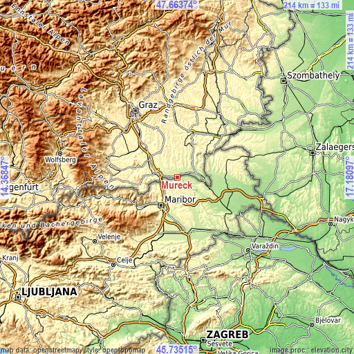
| \ | Map #1 | Topo.Map |
| Scale [m] | 225..399 m | × |
| Scale [ft] | 738..1309 ft | × |
| Average | 272.4 m = 894 ft | × |
| Width | 6.7 km = 4.2 mi | 214.4 km = 133.2 mi |
| Height | 6.7 km = 4.2 mi | 214.4 km = 133.2 mi |
| ↑Max Latitude | 46.738186° | 47.66374° |
| Latitude at center | 46.70806° | 46.70806° |
| ↓Min Latitude | 46.677918° | 45.73515° |
| ← Min Longitude | 15.730775° | 14.36847° |
| Longitude center | 15.77472° | 15.77472° |
| →Max Longitude | 15.818665° | 17.18097° |
Nearby cities:
Cities around Mureck sort by population:
• Straß in Steiermark elevation 255 m
11.7 km,  280°
280°
• Sankt Peter am Ottersbach 273 m
10 km,  353°
353°
• Spielfeld 258 m
10.5 km,  268°
268°
• Sankt Veit am Vogau 267 m
10.7 km,  289°
289°
• Ratschendorf 243 m
4.9 km,  39°
39°
• Gosdorf 233 m
2.6 km,  31°
31°
• Mettersdorf am Saßbach 279 m
11.9 km,  335°
335°
• Deutsch Goritz 244 m
6.3 km, 41°
• Dietersdorf am Gnasbach 277 m
11.6 km,  14°
14°
• Weinburg am Saßbach 254 m
6.5 km,  321°
321°
• Eichfeld 238 m
2 km, 345°
• Trössing 268 m
12.5 km, 14°
Multilingual:
 En español:
Mureck elevación 237 m.
 En France:
Mureck élévation 237 m.


Sources and notes:
- [note 1] Map square and city borders are not equal. Map elevation data is calculated only from area inside that square.
- [src 1] Elevation data from geonames database provided with same terms of usage.
- [src 2] The elevation map of Mureck is generated using elevation data from NASA's 3 arcsec (90m) resolution SRTM data.
- [src 3] Base (background) map © OpenStreetMap contributors tiles are generated by Geofabrik and OpenTopoMap.
Copyright & License:
This Mureck Elevation Map is licensed under CC BY-SA. You may reuse any part from this page, if you give a proper credit by linking to this URL:
 More info on terms of use page.