Mürzzuschlag elevation
Mürzzuschlag (Styria, Politischer Bezirk Bruck-Mürzzuschlag), Austria elevation is 716 meters and Mürzzuschlag elevation in feet is 2349 ft above sea level [src 1]. Mürzzuschlag is a seat of a third-order administrative division (feature code) with elevation that is 207 meters (679 ft) bigger than average city elevation in Austria.
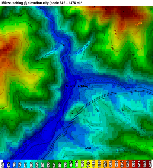
Below is the Elevation map of Mürzzuschlag, which displays elevation range with different colors. Scale of the first map is from 642 to 1478 m (2106 to 4849 ft) with average elevation of 898.3 meters (=2947 ft) [note 1]
These maps also provides idea of topography and contour of this city, they are displayed at different zoom levels. More info about maps, scale and edge coordinates you can find below images.
| \ | Map #1 | Map #2 | Topo.Map |
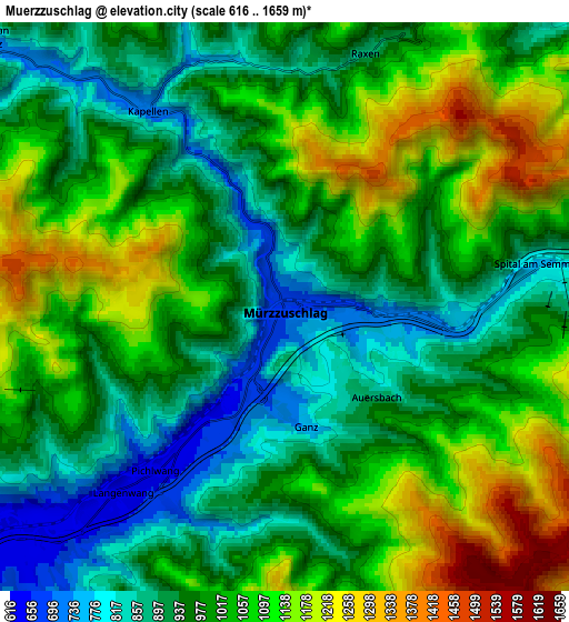
| Scale [m] | 642..1478 m | 616..1659 m | × |
| Scale [ft] | 2106..4849 ft | 2021..5443 ft | × |
| Average | 898.3 m = 2947 ft | 1005.5 m = 3299 ft | × |
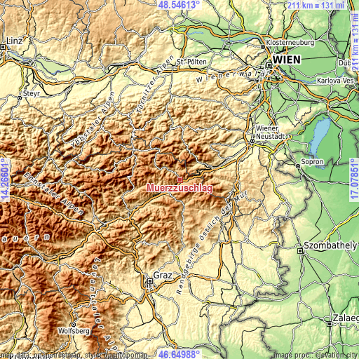
| Width | 6.59 km = 4.1 mi | 13.18 km = 8.2 mi | 210.8 km = 131 mi |
| Height | 6.59 km = 4.1 mi | 13.18 km = 8.2 mi | 210.8 km = 131 mi |
| ↑Max Latitude | 47.63622° | 47.665824° | 48.54613° |
| Latitude at center | 47.6066° | 47.6066° | 47.6066° |
| ↓Min Latitude | 47.576963° | 47.547309° | 46.64988° |
| ← Min Longitude | 15.628315° | 15.584369° | 14.26601° |
| Longitude center | 15.67226° | 15.67226° | 15.67226° |
| →Max Longitude | 15.716205° | 15.760151° | 17.07851° |
Nearby cities:
Cities around Mürzzuschlag sort by population:
• Langenwang elevation 630 m
6.1 km,  223°
223°
• Krieglach 608 m
10.6 km,  231°
231°
• Hönigsberg 662 m
3.4 km,  211°
211°
• Spital am Semmering 790 m
5.9 km,  82°
82°
• Rettenegg 857 m
12 km,  137°
137°
• Semmering 986 m
12.2 km, 75°
• Sankt Kathrein am Hauenstein 805 m
13.1 km,  172°
172°
• Kapellen 701 m
5.6 km,  324°
324°
• Ganz 805 m
1.1 km,  131°
131°
• Klaffenegg 1018 m
11.8 km,  146°
146°
• Sticklberg 900 m
11.7 km, 136°
• Neuberg an der Mürz 729 m
9.9 km,  310°
310°
Multilingual:
 En español:
Mürzzuschlag elevación 716 m.
 En France:
Mürzzuschlag élévation 716 m.
 Auf Deutsch:
Mürzzuschlag höhe über dem Meeresspiegel ist 716 m.

Sources and notes:
- [note 1] Map square and city borders are not equal. Map elevation data is calculated only from area inside that square.
- [src 1] Elevation data from geonames database provided with same terms of usage.
- [src 2] The elevation map of Mürzzuschlag is generated using elevation data from NASA's 3 arcsec (90m) resolution SRTM data.
- [src 3] Base (background) map © OpenStreetMap contributors tiles are generated by Geofabrik and OpenTopoMap.
Copyright & License:
This Mürzzuschlag Elevation Map is licensed under CC BY-SA. You may reuse any part from this page, if you give a proper credit by linking to this URL:
 More info on terms of use page.