Pfaffenhofen elevation
Pfaffenhofen (Tyrol, Politischer Bezirk Innsbruck Land), Austria elevation is 634 meters and Pfaffenhofen elevation in feet is 2080 ft above sea level [src 1]. Pfaffenhofen is a seat of a third-order administrative division (feature code) with elevation that is 125 meters (410 ft) bigger than average city elevation in Austria.
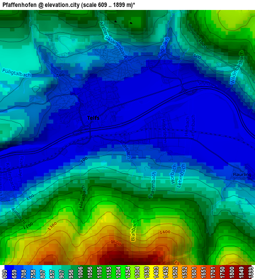
Below is the Elevation map of Pfaffenhofen, which displays elevation range with different colors. Scale of the first map is from 609 to 1899 m (1998 to 6230 ft) with average elevation of 905.3 meters (=2970 ft) [note 1]
These maps also provides idea of topography and contour of this city, they are displayed at different zoom levels. More info about maps, scale and edge coordinates you can find below images.
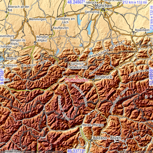
| \ | Map #1 | Topo.Map |
| Scale [m] | 609..1899 m | × |
| Scale [ft] | 1998..6230 ft | × |
| Average | 905.3 m = 2970 ft | × |
| Width | 6.63 km = 4.1 mi | 212.1 km = 131.8 mi |
| Height | 6.63 km = 4.1 mi | 212.1 km = 131.8 mi |
| ↑Max Latitude | 47.329794° | 48.24507° |
| Latitude at center | 47.3° | 47.3° |
| ↓Min Latitude | 47.27019° | 46.33773° |
| ← Min Longitude | 11.039385° | 9.67708° |
| Longitude center | 11.08333° | 11.08333° |
| →Max Longitude | 11.127275° | 12.48958° |
Nearby cities:
Cities around Pfaffenhofen sort by population:
• Telfs elevation 637 m
1.4 km,  304°
304°
• Seefeld in Tirol 1178 m
8.6 km,  66°
66°
• Rietz 698 m
4.3 km,  248°
248°
• Oberhofen im Inntal 634 m
0 km,  0°
0°
• Stams 683 m
8 km, 250°
• Obermieming 849 m
7.5 km,  270°
270°
• Hatting 611 m
6.8 km,  110°
110°
• Flaurling 659 m
3.2 km, 107°
• Pettnau 610 m
5.8 km,  98°
98°
• Polling in Tirol 605 m
5.4 km, 110°
• Wildermieming 858 m
5.4 km,  290°
290°
• Mieming 849 m
7.5 km, 270°
Multilingual:
 En español:
Pfaffenhofen elevación 634 m.
 En France:
Pfaffenhofen élévation 634 m.
 Auf Deutsch:
Pfaffenhofen höhe über dem Meeresspiegel ist 634 m.

Sources and notes:
- [note 1] Map square and city borders are not equal. Map elevation data is calculated only from area inside that square.
- [src 1] Elevation data from geonames database provided with same terms of usage.
- [src 2] The elevation map of Pfaffenhofen is generated using elevation data from NASA's 3 arcsec (90m) resolution SRTM data.
- [src 3] Base (background) map © OpenStreetMap contributors tiles are generated by Geofabrik and OpenTopoMap.
Copyright & License:
This Pfaffenhofen Elevation Map is licensed under CC BY-SA. You may reuse any part from this page, if you give a proper credit by linking to this URL:
 More info on terms of use page.