Potzneusiedl elevation
Potzneusiedl (Burgenland, Politischer Bezirk Neusiedl am See), Austria elevation is 154 meters and Potzneusiedl elevation in feet is 505 ft above sea level [src 1]. Potzneusiedl is a seat of a third-order administrative division (feature code) with elevation that is 355 meters (1165 ft) smaller than average city elevation in Austria.
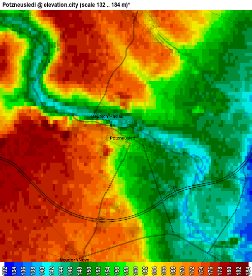
Below is the Elevation map of Potzneusiedl, which displays elevation range with different colors. Scale of the first map is from 132 to 184 m (433 to 604 ft) with average elevation of 160.5 meters (=527 ft) [note 1]
These maps also provides idea of topography and contour of this city, they are displayed at different zoom levels. More info about maps, scale and edge coordinates you can find below images.
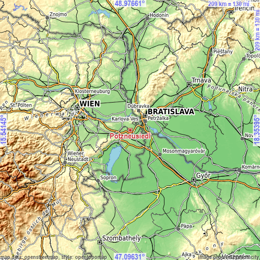
| \ | Map #1 | Topo.Map |
| Scale [m] | 132..184 m | × |
| Scale [ft] | 433..604 ft | × |
| Average | 160.5 m = 527 ft | × |
| Width | 6.53 km = 4.1 mi | 209.1 km = 129.9 mi |
| Height | 6.53 km = 4.1 mi | 209.1 km = 129.9 mi |
| ↑Max Latitude | 48.074411° | 48.97661° |
| Latitude at center | 48.04504° | 48.04504° |
| ↓Min Latitude | 48.015652° | 47.09631° |
| ← Min Longitude | 16.903755° | 15.54145° |
| Longitude center | 16.9477° | 16.9477° |
| →Max Longitude | 16.991645° | 18.35395° |
Nearby cities:
Cities around Potzneusiedl sort by population:
• Parndorf elevation 181 m
8.2 km,  232°
232°
• Kittsee 136 m
10.1 km,  58°
58°
• Zurndorf 137 m
8 km,  149°
149°
• Bad Deutsch-Altenburg 149 m
10.4 km,  342°
342°
• Gattendorf 141 m
4.1 km,  139°
139°
• Petronell-Carnuntum 177 m
9.7 km,  321°
321°
• Pama 134 m
6.4 km,  85°
85°
• Prellenkirchen 171 m
3.2 km,  6°
6°
• Berg 148 m
9.2 km,  47°
47°
• Edelstal 194 m
6.7 km,  23°
23°
• Hundsheim 214 m
8.1 km,  353°
353°
• Rohrau 144 m
7.6 km,  288°
288°
Multilingual:
 En español:
Potzneusiedl elevación 154 m.
 En France:
Potzneusiedl élévation 154 m.
 Auf Deutsch:
Potzneusiedl höhe über dem Meeresspiegel ist 154 m.

Sources and notes:
- [note 1] Map square and city borders are not equal. Map elevation data is calculated only from area inside that square.
- [src 1] Elevation data from geonames database provided with same terms of usage.
- [src 2] The elevation map of Potzneusiedl is generated using elevation data from NASA's 3 arcsec (90m) resolution SRTM data.
- [src 3] Base (background) map © OpenStreetMap contributors tiles are generated by Geofabrik and OpenTopoMap.
Copyright & License:
This Potzneusiedl Elevation Map is licensed under CC BY-SA. You may reuse any part from this page, if you give a proper credit by linking to this URL:
 More info on terms of use page.