Puchenstuben elevation
Puchenstuben (Lower Austria, Politischer Bezirk Scheibbs), Austria elevation is 862 meters and Puchenstuben elevation in feet is 2828 ft above sea level [src 1]. Puchenstuben is a seat of a third-order administrative division (feature code) with elevation that is 353 meters (1158 ft) bigger than average city elevation in Austria.
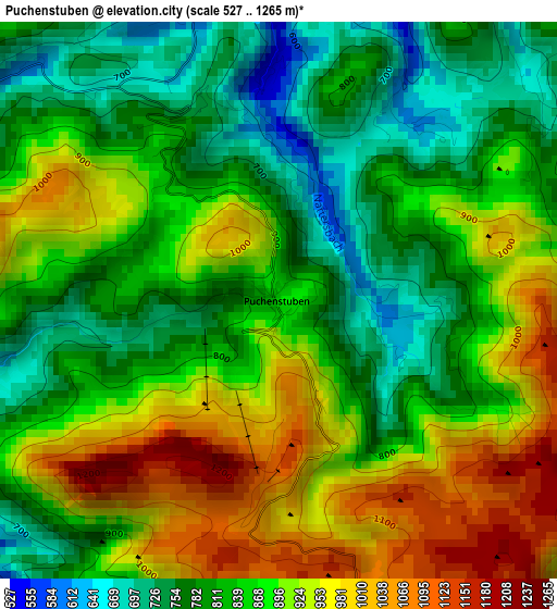
Below is the Elevation map of Puchenstuben, which displays elevation range with different colors. Scale of the first map is from 527 to 1265 m (1729 to 4150 ft) with average elevation of 863.3 meters (=2832 ft) [note 1]
These maps also provides idea of topography and contour of this city, they are displayed at different zoom levels. More info about maps, scale and edge coordinates you can find below images.
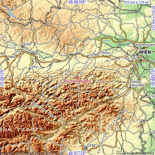
| \ | Map #1 | Topo.Map |
| Scale [m] | 527..1265 m | × |
| Scale [ft] | 1729..4150 ft | × |
| Average | 863.3 m = 2832 ft | × |
| Width | 6.55 km = 4.1 mi | 209.5 km = 130.2 mi |
| Height | 6.55 km = 4.1 mi | 209.5 km = 130.2 mi |
| ↑Max Latitude | 47.957628° | 48.86189° |
| Latitude at center | 47.92819° | 47.92819° |
| ↓Min Latitude | 47.898736° | 46.97732° |
| ← Min Longitude | 15.243535° | 13.88123° |
| Longitude center | 15.28748° | 15.28748° |
| →Max Longitude | 15.331425° | 16.69373° |
Nearby cities:
Cities around Puchenstuben sort by population:
• Scheibbs elevation 344 m
12.3 km,  313°
313°
• Gaming 427 m
14.8 km,  270°
270°
• Türnitz 457 m
15.3 km,  88°
88°
• Kirchberg an der Pielach 371 m
15.2 km,  43°
43°
• Oberndorf an der Melk 321 m
15.8 km,  342°
342°
• Kirnberg an der Mank 329 m
16.2 km,  9°
9°
• Sankt Georgen an der Leys 380 m
12.3 km, 338°
• Frankenfels 458 m
6.7 km,  25°
25°
• Loich 435 m
11.3 km,  48°
48°
• Mitterbach am Erlaufsee 789 m
12.7 km,  177°
177°
• Annaberg 979 m
9.2 km,  133°
133°
• Schwarzenbach an der Pielach 750 m
7.2 km, 85°
Multilingual:
 En español:
Puchenstuben elevación 862 m.
 En France:
Puchenstuben élévation 862 m.
 Auf Deutsch:
Puchenstuben höhe über dem Meeresspiegel ist 862 m.

Sources and notes:
- [note 1] Map square and city borders are not equal. Map elevation data is calculated only from area inside that square.
- [src 1] Elevation data from geonames database provided with same terms of usage.
- [src 2] The elevation map of Puchenstuben is generated using elevation data from NASA's 3 arcsec (90m) resolution SRTM data.
- [src 3] Base (background) map © OpenStreetMap contributors tiles are generated by Geofabrik and OpenTopoMap.
Copyright & License:
This Puchenstuben Elevation Map is licensed under CC BY-SA. You may reuse any part from this page, if you give a proper credit by linking to this URL:
 More info on terms of use page.