Ramsau elevation
Ramsau (Lower Austria, Politischer Bezirk Lilienfeld), Austria elevation is 466 meters and Ramsau elevation in feet is 1529 ft above sea level [src 1]. Ramsau is a seat of a third-order administrative division (feature code) with elevation that is 43 meters (141 ft) smaller than average city elevation in Austria.
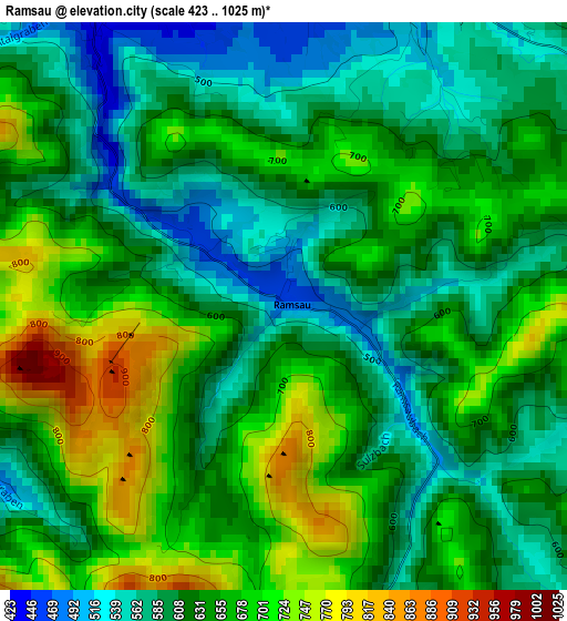
Below is the Elevation map of Ramsau, which displays elevation range with different colors. Scale of the first map is from 423 to 1025 m (1388 to 3363 ft) with average elevation of 633.5 meters (=2078 ft) [note 1]
These maps also provides idea of topography and contour of this city, they are displayed at different zoom levels. More info about maps, scale and edge coordinates you can find below images.
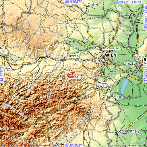
| \ | Map #1 | Topo.Map |
| Scale [m] | 423..1025 m | × |
| Scale [ft] | 1388..3363 ft | × |
| Average | 633.5 m = 2078 ft | × |
| Width | 6.54 km = 4.1 mi | 209.2 km = 130 mi |
| Height | 6.54 km = 4.1 mi | 209.2 km = 130 mi |
| ↑Max Latitude | 48.032525° | 48.93547° |
| Latitude at center | 48.00313° | 48.00313° |
| ↓Min Latitude | 47.973718° | 47.05363° |
| ← Min Longitude | 15.759375° | 14.39707° |
| Longitude center | 15.80332° | 15.80332° |
| →Max Longitude | 15.847265° | 17.20957° |
Nearby cities:
Cities around Ramsau sort by population:
• Hainfeld elevation 423 m
4.1 km,  327°
327°
• Rohrbach an der Gölsen 400 m
6.7 km,  316°
316°
• Sankt Veit an der Gölsen 367 m
10.9 km,  294°
294°
• Kleinzell 468 m
5.6 km,  242°
242°
• Kaumberg 477 m
7.4 km,  71°
71°
• Altenmarkt an der Triesting 393 m
14.4 km,  84°
84°
• Rohr im Gebirge 673 m
13.1 km,  202°
202°
• Lilienfeld 378 m
15.4 km,  274°
274°
• Muggendorf 450 m
14.2 km,  136°
136°
• Gutenstein 480 m
15.5 km,  155°
155°
• Furth an der Triesting 425 m
13.1 km,  104°
104°
• Stössing 342 m
13.3 km,  3°
3°
Multilingual:
 En español:
Ramsau elevación 466 m.
 En France:
Ramsau élévation 466 m.


Sources and notes:
- [note 1] Map square and city borders are not equal. Map elevation data is calculated only from area inside that square.
- [src 1] Elevation data from geonames database provided with same terms of usage.
- [src 2] The elevation map of Ramsau is generated using elevation data from NASA's 3 arcsec (90m) resolution SRTM data.
- [src 3] Base (background) map © OpenStreetMap contributors tiles are generated by Geofabrik and OpenTopoMap.
Copyright & License:
This Ramsau Elevation Map is licensed under CC BY-SA. You may reuse any part from this page, if you give a proper credit by linking to this URL:
 More info on terms of use page.