Rauchenwarth elevation
Rauchenwarth (Lower Austria, Politischer Bezirk Bruck an der Leitha), Austria elevation is 206 meters and Rauchenwarth elevation in feet is 676 ft above sea level [src 1]. Rauchenwarth is a seat of a third-order administrative division (feature code) with elevation that is 303 meters (994 ft) smaller than average city elevation in Austria.
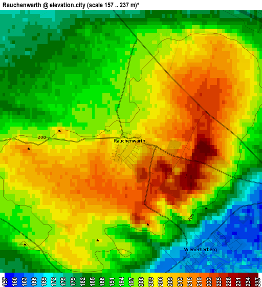
Below is the Elevation map of Rauchenwarth, which displays elevation range with different colors. Scale of the first map is from 157 to 237 m (515 to 778 ft) with average elevation of 198.2 meters (=650 ft) [note 1]
These maps also provides idea of topography and contour of this city, they are displayed at different zoom levels. More info about maps, scale and edge coordinates you can find below images.
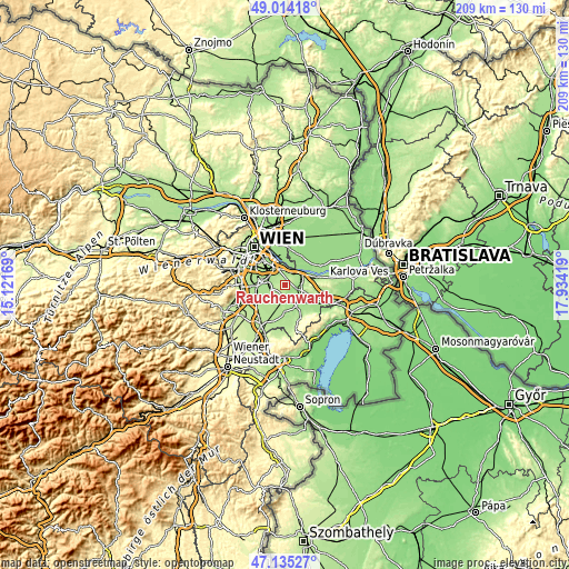
| \ | Map #1 | Topo.Map |
| Scale [m] | 157..237 m | × |
| Scale [ft] | 515..778 ft | × |
| Average | 198.2 m = 650 ft | × |
| Width | 6.53 km = 4.1 mi | 208.9 km = 129.8 mi |
| Height | 6.53 km = 4.1 mi | 208.9 km = 129.8 mi |
| ↑Max Latitude | 48.112649° | 49.01418° |
| Latitude at center | 48.0833° | 48.0833° |
| ↓Min Latitude | 48.053934° | 47.13527° |
| ← Min Longitude | 16.483995° | 15.12169° |
| Longitude center | 16.52794° | 16.52794° |
| →Max Longitude | 16.571885° | 17.93419° |
Nearby cities:
Cities around Rauchenwarth sort by population:
• Schwechat elevation 163 m
7.2 km,  320°
320°
• Himberg 168 m
7 km,  270°
270°
• Fischamend-Markt 159 m
6.5 km,  55°
55°
• Gramatneusiedl 178 m
6.5 km,  205°
205°
• Rannersdorf 167 m
6.9 km, 316°
• Ebergassing 180 m
4.3 km,  190°
190°
• Schwadorf 164 m
4.1 km,  112°
112°
• Enzersdorf an der Fischa 157 m
6 km,  88°
88°
• Mannswörth 155 m
7 km,  351°
351°
• Lanzendorf 166 m
6.9 km,  296°
296°
• Zwölfaxing 167 m
5.7 km, 301°
• Klein-Neusiedl 157 m
6 km,  78°
78°
Multilingual:
 En español:
Rauchenwarth elevación 206 m.
 En France:
Rauchenwarth élévation 206 m.
 Auf Deutsch:
Rauchenwarth höhe über dem Meeresspiegel ist 206 m.

Sources and notes:
- [note 1] Map square and city borders are not equal. Map elevation data is calculated only from area inside that square.
- [src 1] Elevation data from geonames database provided with same terms of usage.
- [src 2] The elevation map of Rauchenwarth is generated using elevation data from NASA's 3 arcsec (90m) resolution SRTM data.
- [src 3] Base (background) map © OpenStreetMap contributors tiles are generated by Geofabrik and OpenTopoMap.
Copyright & License:
This Rauchenwarth Elevation Map is licensed under CC BY-SA. You may reuse any part from this page, if you give a proper credit by linking to this URL:
 More info on terms of use page.