Ravelsbach elevation
Ravelsbach (Lower Austria, Politischer Bezirk Hollabrunn), Austria elevation is 280 meters and Ravelsbach elevation in feet is 919 ft above sea level [src 1]. Ravelsbach is a seat of a third-order administrative division (feature code) with elevation that is 229 meters (751 ft) smaller than average city elevation in Austria.
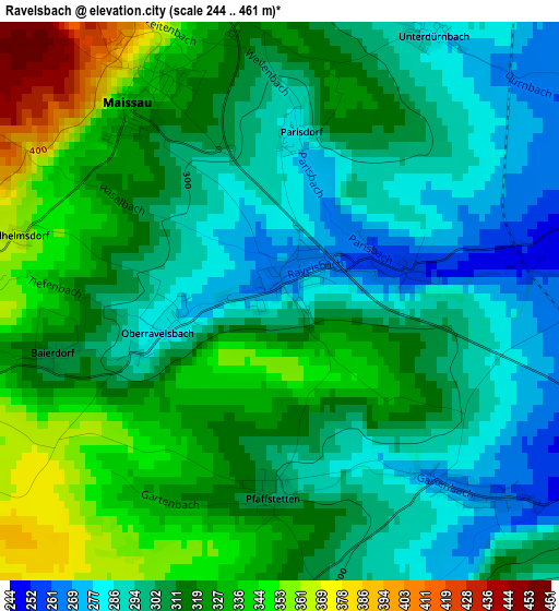
Below is the Elevation map of Ravelsbach, which displays elevation range with different colors. Scale of the first map is from 244 to 461 m (801 to 1512 ft) with average elevation of 311.5 meters (=1022 ft) [note 1]
These maps also provides idea of topography and contour of this city, they are displayed at different zoom levels. More info about maps, scale and edge coordinates you can find below images.
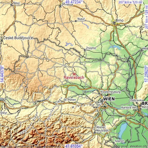
| \ | Map #1 | Topo.Map |
| Scale [m] | 244..461 m | × |
| Scale [ft] | 801..1512 ft | × |
| Average | 311.5 m = 1022 ft | × |
| Width | 6.47 km = 4 mi | 207 km = 128.6 mi |
| Height | 6.47 km = 4 mi | 207 km = 128.6 mi |
| ↑Max Latitude | 48.579082° | 49.47234° |
| Latitude at center | 48.55° | 48.55° |
| ↓Min Latitude | 48.520901° | 47.61054° |
| ← Min Longitude | 15.806055° | 14.44375° |
| Longitude center | 15.85° | 15.85° |
| →Max Longitude | 15.893945° | 17.25625° |
Nearby cities:
Cities around Ravelsbach sort by population:
• Eggenburg elevation 339 m
10.1 km,  347°
347°
• Gars am Kamp 246 m
15.1 km,  286°
286°
• Großweikersdorf 204 m
13.1 km,  131°
131°
• Hadersdorf am Kamp 198 m
14.8 km,  221°
221°
• Ziersdorf 235 m
6.1 km,  111°
111°
• Fels am Wagram 209 m
13.2 km,  190°
190°
• Strass 209 m
12.6 km, 222°
• Kirchberg am Wagram 187 m
13.6 km,  165°
165°
• Maissau 336 m
2.9 km,  330°
330°
• Röschitz 324 m
10.6 km, 347°
• Sitzendorf an der Schmida 241 m
8.7 km,  51°
51°
• Großriedenthal 276 m
7.5 km, 170°
Multilingual:
 En español:
Ravelsbach elevación 280 m.
 En France:
Ravelsbach élévation 280 m.
 Auf Deutsch:
Ravelsbach höhe über dem Meeresspiegel ist 280 m.

Sources and notes:
- [note 1] Map square and city borders are not equal. Map elevation data is calculated only from area inside that square.
- [src 1] Elevation data from geonames database provided with same terms of usage.
- [src 2] The elevation map of Ravelsbach is generated using elevation data from NASA's 3 arcsec (90m) resolution SRTM data.
- [src 3] Base (background) map © OpenStreetMap contributors tiles are generated by Geofabrik and OpenTopoMap.
Copyright & License:
This Ravelsbach Elevation Map is licensed under CC BY-SA. You may reuse any part from this page, if you give a proper credit by linking to this URL:
 More info on terms of use page.