Reutte elevation
Reutte (Tyrol, Politischer Bezirk Reutte), Austria elevation is 856 meters and Reutte elevation in feet is 2808 ft above sea level [src 1]. Reutte is a seat of a third-order administrative division (feature code) with elevation that is 347 meters (1138 ft) bigger than average city elevation in Austria.
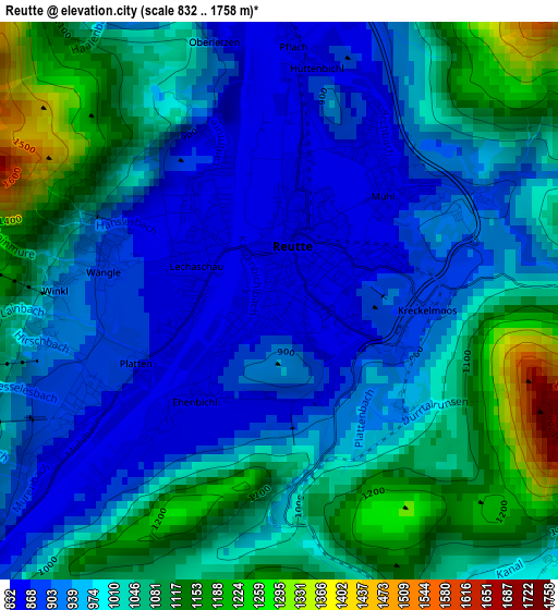
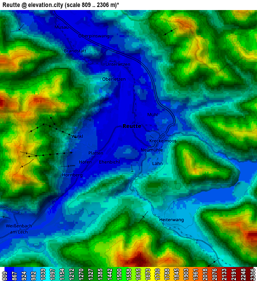
Below is the Elevation map of Reutte, which displays elevation range with different colors. Scale of the first map is from 832 to 1758 m (2730 to 5768 ft) with average elevation of 1001.4 meters (=3285 ft) [note 1]
These maps also provides idea of topography and contour of this city, they are displayed at different zoom levels. More info about maps, scale and edge coordinates you can find below images.
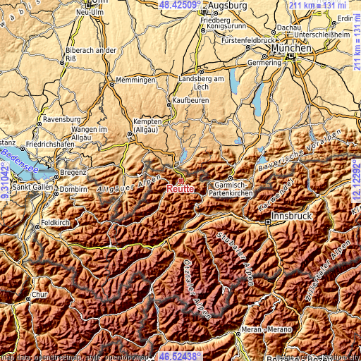
| \ | Map #1 | Map #2 | Topo.Map |
| Scale [m] | 832..1758 m | 809..2306 m | × |
| Scale [ft] | 2730..5768 ft | 2654..7566 ft | × |
| Average | 1001.4 m = 3285 ft | 1210.4 m = 3971 ft | × |
| Width | 6.6 km = 4.1 mi | 13.21 km = 8.2 mi | 211.3 km = 131.3 mi |
| Height | 6.6 km = 4.1 mi | 13.21 km = 8.2 mi | 211.3 km = 131.3 mi |
| ↑Max Latitude | 47.51302° | 47.542693° | 48.42509° |
| Latitude at center | 47.48333° | 47.48333° | 47.48333° |
| ↓Min Latitude | 47.453623° | 47.4239° | 46.52438° |
| ← Min Longitude | 10.672725° | 10.628779° | 9.31042° |
| Longitude center | 10.71667° | 10.71667° | 10.71667° |
| →Max Longitude | 10.760615° | 10.804561° | 12.12292° |
Nearby cities:
Cities around Reutte sort by population:
• Lechaschau elevation 846 m
0.9 km,  304°
304°
• Breitenwang 928 m
1.4 km,  72°
72°
• Weissenbach am Lech 882 m
7.4 km,  230°
230°
• Höfen 860 m
3.1 km, 233°
• Pflach 839 m
3.7 km,  0°
0°
• Ehenbichl 883 m
2.2 km,  214°
214°
• Wängle 884 m
2 km,  280°
280°
• Bichlbach 1081 m
8.9 km,  141°
141°
• Heiterwang 980 m
4.5 km,  145°
145°
• Musau 821 m
6.3 km,  328°
328°
• Nesselwängle 1162 m
7.5 km,  270°
270°
• Berwang 1337 m
8.7 km,  164°
164°
Multilingual:
 En español:
Reutte elevación 856 m.
 En France:
Reutte élévation 856 m.
 Auf Deutsch:
Reutte in Tirol höhe über dem Meeresspiegel ist 856 m.

Sources and notes:
- [note 1] Map square and city borders are not equal. Map elevation data is calculated only from area inside that square.
- [src 1] Elevation data from geonames database provided with same terms of usage.
- [src 2] The elevation map of Reutte is generated using elevation data from NASA's 3 arcsec (90m) resolution SRTM data.
- [src 3] Base (background) map © OpenStreetMap contributors tiles are generated by Geofabrik and OpenTopoMap.
Copyright & License:
This Reutte Elevation Map is licensed under CC BY-SA. You may reuse any part from this page, if you give a proper credit by linking to this URL:
 More info on terms of use page.