Roitham elevation
Roitham (Upper Austria, Politischer Bezirk Gmunden), Austria elevation is 421 meters and Roitham elevation in feet is 1381 ft above sea level [src 1]. Roitham is a seat of a third-order administrative division (feature code) with elevation that is 88 meters (289 ft) smaller than average city elevation in Austria.
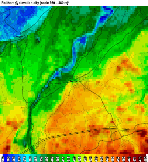
Below is the Elevation map of Roitham, which displays elevation range with different colors. Scale of the first map is from 360 to 480 m (1181 to 1575 ft) with average elevation of 419.6 meters (=1377 ft) [note 1]
These maps also provides idea of topography and contour of this city, they are displayed at different zoom levels. More info about maps, scale and edge coordinates you can find below images.
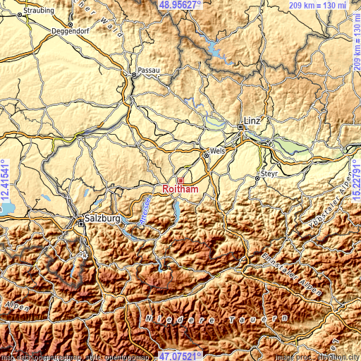
| \ | Map #1 | Topo.Map |
| Scale [m] | 360..480 m | × |
| Scale [ft] | 1181..1575 ft | × |
| Average | 419.6 m = 1377 ft | × |
| Width | 6.54 km = 4.1 mi | 209.2 km = 130 mi |
| Height | 6.54 km = 4.1 mi | 209.1 km = 129.9 mi |
| ↑Max Latitude | 48.053703° | 48.95627° |
| Latitude at center | 48.02432° | 48.02432° |
| ↓Min Latitude | 47.99492° | 47.07521° |
| ← Min Longitude | 13.777715° | 12.41541° |
| Longitude center | 13.82166° | 13.82166° |
| →Max Longitude | 13.865605° | 15.22791° |
Nearby cities:
Cities around Roitham sort by population:
• Laakirchen elevation 439 m
4.7 km,  180°
180°
• Schwanenstadt 390 m
4.9 km,  314°
314°
• Stadl-Traun 349 m
6.8 km,  25°
25°
• Niederstraß 409 m
6.9 km,  260°
260°
• Stadl-Hausruck 354 m
6.9 km,  19°
19°
• Ohlsdorf 533 m
7.4 km,  197°
197°
• Oberndorf bei Schwanenstadt 392 m
5.9 km, 305°
• Rüstorf 378 m
3.2 km, 311°
• Redlham 401 m
5.5 km,  270°
270°
• Desselbrunn 423 m
3.8 km, 265°
• Schlatt 404 m
5.8 km,  335°
335°
• Stadl-Paura 360 m
7.4 km, 27°
Multilingual:
 En español:
Roitham elevación 421 m.
 En France:
Roitham élévation 421 m.


Sources and notes:
- [note 1] Map square and city borders are not equal. Map elevation data is calculated only from area inside that square.
- [src 1] Elevation data from geonames database provided with same terms of usage.
- [src 2] The elevation map of Roitham is generated using elevation data from NASA's 3 arcsec (90m) resolution SRTM data.
- [src 3] Base (background) map © OpenStreetMap contributors tiles are generated by Geofabrik and OpenTopoMap.
Copyright & License:
This Roitham Elevation Map is licensed under CC BY-SA. You may reuse any part from this page, if you give a proper credit by linking to this URL:
 More info on terms of use page.