Sankt Veit im Pongau elevation
Sankt Veit im Pongau (Salzburg, Politischer Bezirk Sankt Johann im Pongau), Austria elevation is 763 meters and Sankt Veit im Pongau elevation in feet is 2503 ft above sea level [src 1]. Sankt Veit im Pongau is a seat of a third-order administrative division (feature code) with elevation that is 254 meters (833 ft) bigger than average city elevation in Austria.
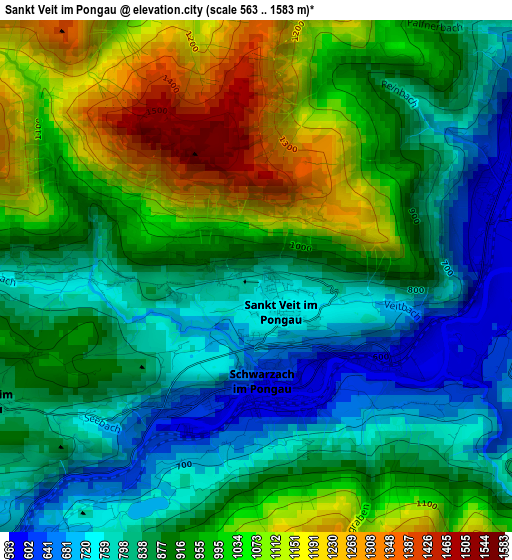
Below is the Elevation map of Sankt Veit im Pongau, which displays elevation range with different colors. Scale of the first map is from 563 to 1583 m (1847 to 5194 ft) with average elevation of 919.7 meters (=3017 ft) [note 1]
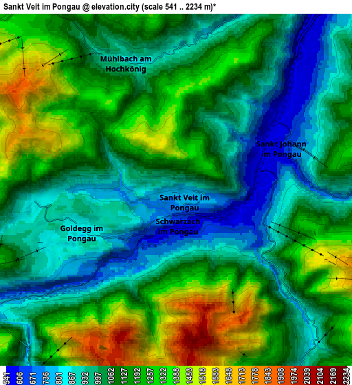
These maps also provides idea of topography and contour of this city, they are displayed at different zoom levels. More info about maps, scale and edge coordinates you can find below images.
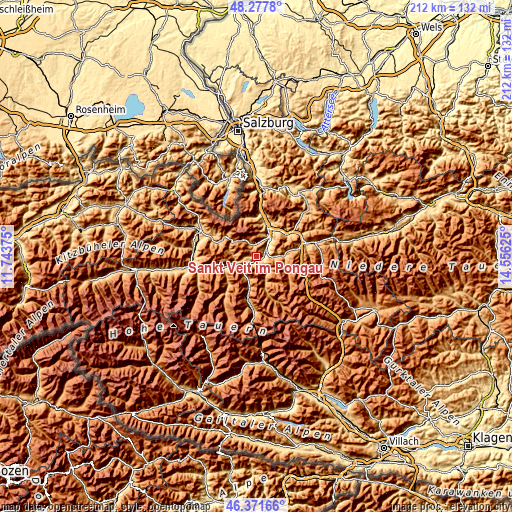
| \ | Map #1 | Map #2 | Topo.Map |
| Scale [m] | 563..1583 m | 541..2234 m | × |
| Scale [ft] | 1847..5194 ft | 1775..7329 ft | × |
| Average | 919.7 m = 3017 ft | 1102.5 m = 3617 ft | × |
| Width | 6.62 km = 4.1 mi | 13.25 km = 8.2 mi | 211.9 km = 131.7 mi |
| Height | 6.62 km = 4.1 mi | 13.25 km = 8.2 mi | 211.9 km = 131.7 mi |
| ↑Max Latitude | 47.363105° | 47.392863° | 48.2778° |
| Latitude at center | 47.33333° | 47.33333° | 47.33333° |
| ↓Min Latitude | 47.303538° | 47.27373° | 46.37166° |
| ← Min Longitude | 13.106055° | 13.062109° | 11.74375° |
| Longitude center | 13.15° | 13.15° | 13.15° |
| →Max Longitude | 13.193945° | 13.237891° | 14.55625° |
Nearby cities:
Cities around Sankt Veit im Pongau sort by population:
• Bischofshofen elevation 558 m
10.5 km,  28°
28°
• Sankt Johann im Pongau 597 m
4.2 km,  63°
63°
• Grossarl 916 m
11.7 km,  161°
161°
• Schwarzach im Pongau 594 m
1.4 km,  174°
174°
• Reinbach 594 m
3.4 km, 64°
• Plankenau 856 m
3.3 km,  102°
102°
• Mitterberghütten 564 m
9 km, 34°
• Mühlbach am Hochkönig 886 m
5.1 km,  342°
342°
• Dorfgastein 819 m
10.8 km,  199°
199°
• Lend 640 m
8.4 km,  242°
242°
• Wagrain 849 m
11.2 km,  88°
88°
• Goldegg 822 m
4.2 km,  247°
247°
Multilingual:
 En español:
Sankt Veit im Pongau elevación 763 m.
 En France:
Sankt Veit im Pongau élévation 763 m.
 Auf Deutsch:
St. Veit im Pongau, St. Veit höhe über dem Meeresspiegel ist 763 m.
 На русском:
Санкт-Вайт (Понгау) высота над уровнем моря 763 м
Sources and notes:
- [note 1] Map square and city borders are not equal. Map elevation data is calculated only from area inside that square.
- [src 1] Elevation data from geonames database provided with same terms of usage.
- [src 2] The elevation map of Sankt Veit im Pongau is generated using elevation data from NASA's 3 arcsec (90m) resolution SRTM data.
- [src 3] Base (background) map © OpenStreetMap contributors tiles are generated by Geofabrik and OpenTopoMap.
Copyright & License:
This Sankt Veit im Pongau Elevation Map is licensed under CC BY-SA. You may reuse any part from this page, if you give a proper credit by linking to this URL:
 More info on terms of use page.