Stans elevation
Stans (Tyrol, Politischer Bezirk Schwaz), Austria elevation is 555 meters and Stans elevation in feet is 1821 ft above sea level [src 1]. Stans is a seat of a third-order administrative division (feature code) with elevation that is 46 meters (151 ft) bigger than average city elevation in Austria.
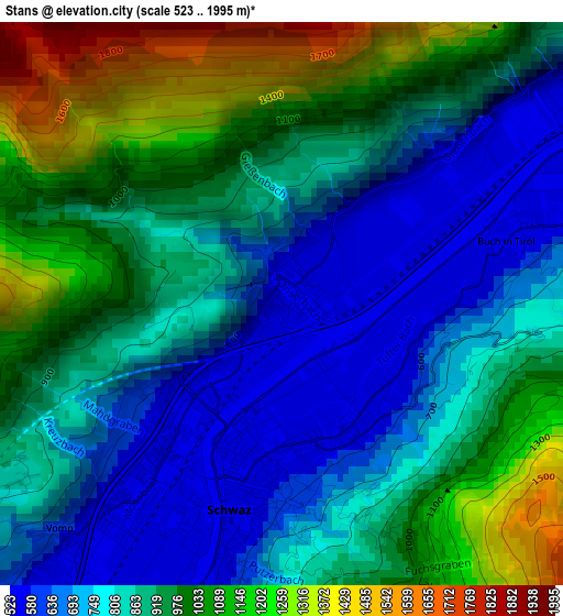
Below is the Elevation map of Stans, which displays elevation range with different colors. Scale of the first map is from 523 to 1995 m (1716 to 6545 ft) with average elevation of 891.7 meters (=2926 ft) [note 1]
These maps also provides idea of topography and contour of this city, they are displayed at different zoom levels. More info about maps, scale and edge coordinates you can find below images.
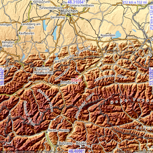
| \ | Map #1 | Topo.Map |
| Scale [m] | 523..1995 m | × |
| Scale [ft] | 1716..6545 ft | × |
| Average | 891.7 m = 2926 ft | × |
| Width | 6.62 km = 4.1 mi | 211.8 km = 131.6 mi |
| Height | 6.62 km = 4.1 mi | 211.8 km = 131.6 mi |
| ↑Max Latitude | 47.396426° | 48.31054° |
| Latitude at center | 47.36667° | 47.36667° |
| ↓Min Latitude | 47.336897° | 46.4056° |
| ← Min Longitude | 11.672725° | 10.31042° |
| Longitude center | 11.71667° | 11.71667° |
| →Max Longitude | 11.760615° | 13.12292° |
Nearby cities:
Cities around Stans sort by population:
• Schwaz elevation 537 m
1.7 km,  196°
196°
• Jenbach 564 m
5 km,  56°
56°
• Vomp 542 m
4.5 km,  214°
214°
• Buch in Tirol 553 m
2.9 km,  72°
72°
• Maurach 947 m
6.7 km,  24°
24°
• Pill 543 m
5.5 km, 209°
• Fiecht 536 m
2.2 km, 214°
• Wiesing 566 m
7.4 km,  54°
54°
• Strass im Zillertal 524 m
8.4 km, 67°
• Gallzein 895 m
4.1 km,  87°
87°
• Terfens 587 m
7.3 km,  228°
228°
• Eben am Achensee 959 m
6.2 km,  32°
32°
Multilingual:
 En español:
Stans elevación 555 m.
 En France:
Stans élévation 555 m.


Sources and notes:
- [note 1] Map square and city borders are not equal. Map elevation data is calculated only from area inside that square.
- [src 1] Elevation data from geonames database provided with same terms of usage.
- [src 2] The elevation map of Stans is generated using elevation data from NASA's 3 arcsec (90m) resolution SRTM data.
- [src 3] Base (background) map © OpenStreetMap contributors tiles are generated by Geofabrik and OpenTopoMap.
Copyright & License:
This Stans Elevation Map is licensed under CC BY-SA. You may reuse any part from this page, if you give a proper credit by linking to this URL:
 More info on terms of use page.