Stattersdorf elevation
Stattersdorf (Lower Austria, Sankt Pölten Stadt), Austria elevation is 273 meters and Stattersdorf elevation in feet is 896 ft above sea level [src 1]. Stattersdorf is a populated place (feature code) with elevation that is 236 meters (774 ft) smaller than average city elevation in Austria.
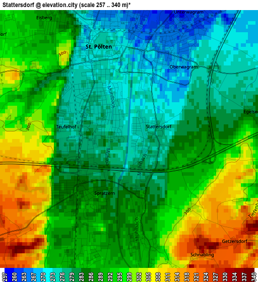
Below is the Elevation map of Stattersdorf, which displays elevation range with different colors. Scale of the first map is from 257 to 340 m (843 to 1115 ft) with average elevation of 288.7 meters (=947 ft) [note 1]
These maps also provides idea of topography and contour of this city, they are displayed at different zoom levels. More info about maps, scale and edge coordinates you can find below images.
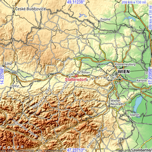
| \ | Map #1 | Topo.Map |
| Scale [m] | 257..340 m | × |
| Scale [ft] | 843..1115 ft | × |
| Average | 288.7 m = 947 ft | × |
| Width | 6.52 km = 4.1 mi | 208.5 km = 129.6 mi |
| Height | 6.52 km = 4.1 mi | 208.5 km = 129.6 mi |
| ↑Max Latitude | 48.212622° | 49.11238° |
| Latitude at center | 48.18333° | 48.18333° |
| ↓Min Latitude | 48.154021° | 47.23713° |
| ← Min Longitude | 15.589385° | 14.22708° |
| Longitude center | 15.63333° | 15.63333° |
| →Max Longitude | 15.677275° | 17.03958° |
Nearby cities:
Cities around Stattersdorf sort by population:
• Sankt Pölten elevation 275 m
1.9 km,  0°
0°
• Spratzern 286 m
1.8 km,  217°
217°
• Viehofen 286 m
3.9 km,  341°
341°
• Oberwagram 267 m
2.3 km,  30°
30°
• Pottenbrunn 248 m
7.4 km,  41°
41°
• Unterwagram 259 m
3.5 km,  20°
20°
• Ratzersdorf an der Traisen 249 m
5.4 km, 27°
• Harland 289 m
2.4 km,  171°
171°
• Hart 294 m
3.6 km,  201°
201°
• Eggendorf 306 m
5.9 km,  189°
189°
• Pyhra 293 m
4.8 km,  124°
124°
• Gerersdorf 279 m
6 km,  288°
288°
Multilingual:
 En español:
Stattersdorf elevación 273 m.
 En France:
Stattersdorf élévation 273 m.
 Auf Deutsch:
Stattersdorf höhe über dem Meeresspiegel ist 273 m.

Sources and notes:
- [note 1] Map square and city borders are not equal. Map elevation data is calculated only from area inside that square.
- [src 1] Elevation data from geonames database provided with same terms of usage.
- [src 2] The elevation map of Stattersdorf is generated using elevation data from NASA's 3 arcsec (90m) resolution SRTM data.
- [src 3] Base (background) map © OpenStreetMap contributors tiles are generated by Geofabrik and OpenTopoMap.
Copyright & License:
This Stattersdorf Elevation Map is licensed under CC BY-SA. You may reuse any part from this page, if you give a proper credit by linking to this URL:
 More info on terms of use page.