Tauplitz elevation
Tauplitz (Styria, Politischer Bezirk Liezen), Austria elevation is 890 meters and Tauplitz elevation in feet is 2920 ft above sea level [src 1]. Tauplitz is a seat of a third-order administrative division (feature code) with elevation that is 381 meters (1250 ft) bigger than average city elevation in Austria.
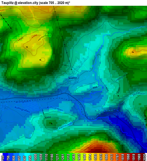
Below is the Elevation map of Tauplitz, which displays elevation range with different colors. Scale of the first map is from 705 to 2020 m (2313 to 6627 ft) with average elevation of 1084.9 meters (=3559 ft) [note 1]
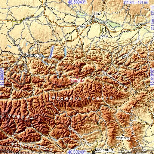
These maps also provides idea of topography and contour of this city, they are displayed at different zoom levels. More info about maps, scale and edge coordinates you can find below images.
| \ | Map #1 | Topo.Map |
| Scale [m] | 705..2020 m | × |
| Scale [ft] | 2313..6627 ft | × |
| Average | 1084.9 m = 3559 ft | × |
| Width | 6.59 km = 4.1 mi | 211 km = 131.1 mi |
| Height | 6.59 km = 4.1 mi | 211 km = 131.1 mi |
| ↑Max Latitude | 47.589697° | 48.50043° |
| Latitude at center | 47.56005° | 47.56005° |
| ↓Min Latitude | 47.530387° | 46.60249° |
| ← Min Longitude | 13.968985° | 12.60668° |
| Longitude center | 14.01293° | 14.01293° |
| →Max Longitude | 14.056875° | 15.41918° |
Nearby cities:
Cities around Tauplitz sort by population:
• Gröbming elevation 768 m
15.5 km,  212°
212°
• Stainach 663 m
7.8 km,  112°
112°
• Weißenbach bei Liezen 635 m
15.3 km,  87°
87°
• Falkenburg 665 m
8.5 km,  141°
141°
• Öblarn 668 m
11.3 km,  188°
188°
• Mitterndorf im Steirischen Salzkammergut 805 m
6.1 km,  265°
265°
• Irdning 662 m
9 km,  132°
132°
• Wörschach 644 m
10.3 km,  96°
96°
• Niederöblarn 676 m
9.3 km,  177°
177°
• Aigen im Ennstal 655 m
10.2 km,  118°
118°
• Donnersbach 694 m
14 km, 141°
• Sankt Martin am Grimming 699 m
8.3 km,  196°
196°
Multilingual:
 En español:
Tauplitz elevación 890 m.
 En France:
Tauplitz élévation 890 m.
 Auf Deutsch:
Tauplitz höhe über dem Meeresspiegel ist 890 m.

Sources and notes:
- [note 1] Map square and city borders are not equal. Map elevation data is calculated only from area inside that square.
- [src 1] Elevation data from geonames database provided with same terms of usage.
- [src 2] The elevation map of Tauplitz is generated using elevation data from NASA's 3 arcsec (90m) resolution SRTM data.
- [src 3] Base (background) map © OpenStreetMap contributors tiles are generated by Geofabrik and OpenTopoMap.
Copyright & License:
This Tauplitz Elevation Map is licensed under CC BY-SA. You may reuse any part from this page, if you give a proper credit by linking to this URL:
 More info on terms of use page.