Thalgau elevation
Thalgau (Salzburg, Politischer Bezirk Salzburg-Umgebung), Austria elevation is 546 meters and Thalgau elevation in feet is 1791 ft above sea level [src 1]. Thalgau is a seat of a third-order administrative division (feature code) with elevation that is 37 meters (121 ft) bigger than average city elevation in Austria.
Below is the Elevation map of Thalgau, which displays elevation range with different colors. Scale of the first map is from 515 to 988 m (1690 to 3241 ft) with average elevation of 680.7 meters (=2233 ft) [note 1]
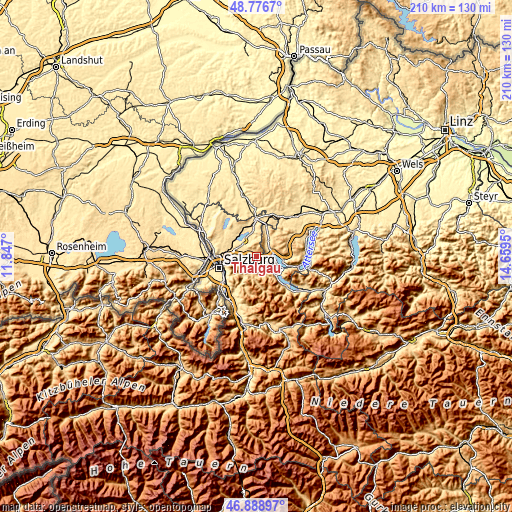
These maps also provides idea of topography and contour of this city, they are displayed at different zoom levels. More info about maps, scale and edge coordinates you can find below images.
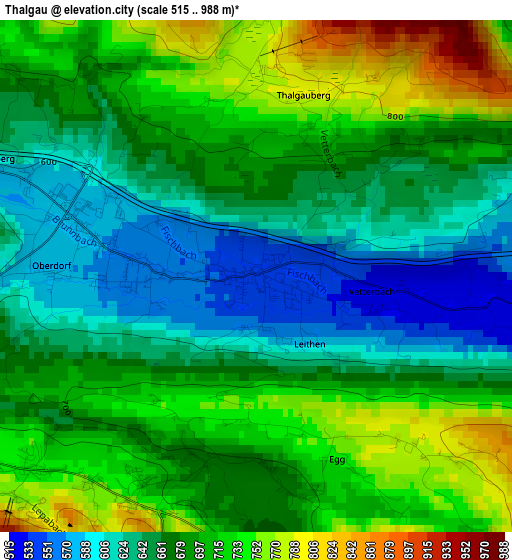
| \ | Map #1 | Topo.Map |
| Scale [m] | 515..988 m | × |
| Scale [ft] | 1690..3241 ft | × |
| Average | 680.7 m = 2233 ft | × |
| Width | 6.56 km = 4.1 mi | 209.9 km = 130.4 mi |
| Height | 6.56 km = 4.1 mi | 209.9 km = 130.4 mi |
| ↑Max Latitude | 47.870907° | 48.7767° |
| Latitude at center | 47.84142° | 47.84142° |
| ↓Min Latitude | 47.811916° | 46.88897° |
| ← Min Longitude | 13.209305° | 11.847° |
| Longitude center | 13.25325° | 13.25325° |
| →Max Longitude | 13.297195° | 14.6595° |
Nearby cities:
Cities around Thalgau sort by population:
• Mondsee elevation 496 m
7.3 km,  76°
76°
• Hof bei Salzburg 737 m
3.8 km,  229°
229°
• Tiefgraben 566 m
5.3 km,  47°
47°
• Sankt Lorenz 490 m
7.2 km,  98°
98°
• Fuschl am See 685 m
5.8 km,  142°
142°
• Plainfeld 621 m
5.3 km,  260°
260°
• Hof 539 m
5.5 km,  59°
59°
• Reitberg 622 m
7.3 km,  279°
279°
• Habach 696 m
7.3 km,  248°
248°
• Zell am Moos 574 m
8 km,  35°
35°
• Faistenau 785 m
7.2 km,  191°
191°
• Ebenau 604 m
8.1 km, 225°
Multilingual:
 En español:
Thalgau elevación 546 m.
 En France:
Thalgau élévation 546 m.


Sources and notes:
- [note 1] Map square and city borders are not equal. Map elevation data is calculated only from area inside that square.
- [src 1] Elevation data from geonames database provided with same terms of usage.
- [src 2] The elevation map of Thalgau is generated using elevation data from NASA's 3 arcsec (90m) resolution SRTM data.
- [src 3] Base (background) map © OpenStreetMap contributors tiles are generated by Geofabrik and OpenTopoMap.
Copyright & License:
This Thalgau Elevation Map is licensed under CC BY-SA. You may reuse any part from this page, if you give a proper credit by linking to this URL:
 More info on terms of use page.