Vorderhornbach elevation
Vorderhornbach (Tyrol, Politischer Bezirk Reutte), Austria elevation is 976 meters and Vorderhornbach elevation in feet is 3202 ft above sea level [src 1]. Vorderhornbach is a seat of a third-order administrative division (feature code) with elevation that is 467 meters (1532 ft) bigger than average city elevation in Austria.
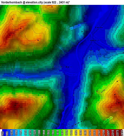
Below is the Elevation map of Vorderhornbach, which displays elevation range with different colors. Scale of the first map is from 922 to 2431 m (3025 to 7976 ft) with average elevation of 1425.5 meters (=4677 ft) [note 1]
These maps also provides idea of topography and contour of this city, they are displayed at different zoom levels. More info about maps, scale and edge coordinates you can find below images.
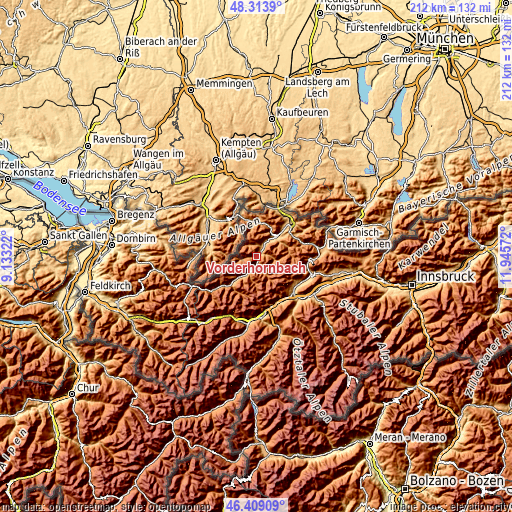
| \ | Map #1 | Topo.Map |
| Scale [m] | 922..2431 m | × |
| Scale [ft] | 3025..7976 ft | × |
| Average | 1425.5 m = 4677 ft | × |
| Width | 6.62 km = 4.1 mi | 211.8 km = 131.6 mi |
| Height | 6.62 km = 4.1 mi | 211.8 km = 131.6 mi |
| ↑Max Latitude | 47.399844° | 48.3139° |
| Latitude at center | 47.37009° | 47.37009° |
| ↓Min Latitude | 47.340319° | 46.40909° |
| ← Min Longitude | 10.495525° | 9.13322° |
| Longitude center | 10.53947° | 10.53947° |
| →Max Longitude | 10.583415° | 11.94572° |
Nearby cities:
Cities around Vorderhornbach sort by population:
• Weissenbach am Lech elevation 882 m
11 km,  43°
43°
• Höfen 860 m
15.2 km,  45°
45°
• Tannheim 1099 m
14.5 km,  353°
353°
• Häselgehr 1016 m
6.6 km,  206°
206°
• Stanzach 961 m
2.5 km, 54°
• Elbigenalp 1053 m
11.8 km,  221°
221°
• Nesselwängle 1162 m
13.9 km,  24°
24°
• Grän 1114 m
14.5 km,  3°
3°
• Elmen 985 m
3.3 km,  175°
175°
• Forchach 912 m
6.1 km,  32°
32°
• Gramais 1293 m
11.5 km, 182°
• Namlos 1445 m
9.8 km,  103°
103°
Multilingual:
 En español:
Vorderhornbach elevación 976 m.
 En France:
Vorderhornbach élévation 976 m.
 Auf Deutsch:
Vorderhornbach höhe über dem Meeresspiegel ist 976 m.

Sources and notes:
- [note 1] Map square and city borders are not equal. Map elevation data is calculated only from area inside that square.
- [src 1] Elevation data from geonames database provided with same terms of usage.
- [src 2] The elevation map of Vorderhornbach is generated using elevation data from NASA's 3 arcsec (90m) resolution SRTM data.
- [src 3] Base (background) map © OpenStreetMap contributors tiles are generated by Geofabrik and OpenTopoMap.
Copyright & License:
This Vorderhornbach Elevation Map is licensed under CC BY-SA. You may reuse any part from this page, if you give a proper credit by linking to this URL:
 More info on terms of use page.