Vorderthiersee elevation
Vorderthiersee (Tyrol, Politischer Bezirk Kufstein), Austria elevation is 823 meters and Vorderthiersee elevation in feet is 2700 ft above sea level [src 1]. Vorderthiersee is a populated place (feature code) with elevation that is 314 meters (1030 ft) bigger than average city elevation in Austria.
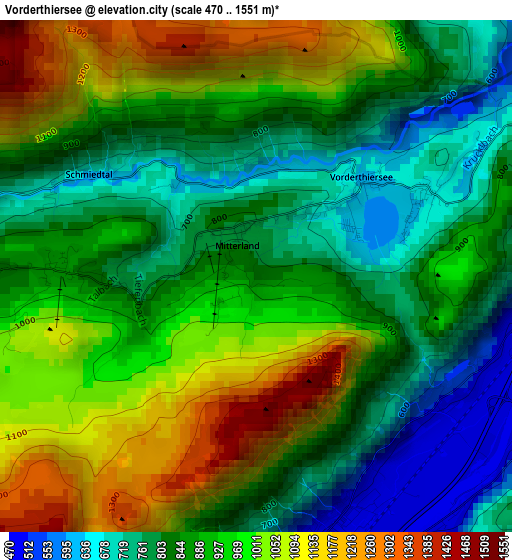
Below is the Elevation map of Vorderthiersee, which displays elevation range with different colors. Scale of the first map is from 470 to 1551 m (1542 to 5089 ft) with average elevation of 905.8 meters (=2972 ft) [note 1]
These maps also provides idea of topography and contour of this city, they are displayed at different zoom levels. More info about maps, scale and edge coordinates you can find below images.
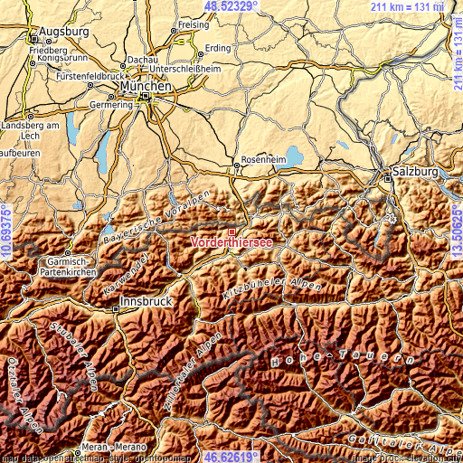
| \ | Map #1 | Topo.Map |
| Scale [m] | 470..1551 m | × |
| Scale [ft] | 1542..5089 ft | × |
| Average | 905.8 m = 2972 ft | × |
| Width | 6.59 km = 4.1 mi | 210.9 km = 131 mi |
| Height | 6.59 km = 4.1 mi | 210.9 km = 131 mi |
| ↑Max Latitude | 47.612963° | 48.52329° |
| Latitude at center | 47.58333° | 47.58333° |
| ↓Min Latitude | 47.55368° | 46.62619° |
| ← Min Longitude | 12.056055° | 10.69375° |
| Longitude center | 12.1° | 12.1° |
| →Max Longitude | 12.143945° | 13.50625° |
Nearby cities:
Cities around Vorderthiersee sort by population:
• Kufstein elevation 483 m
5 km,  90°
90°
• Kirchbichl 529 m
7.3 km,  182°
182°
• Zell 516 m
3.7 km, 90°
• Schwoich 571 m
5.1 km,  143°
143°
• Endach 492 m
4.5 km,  112°
112°
• Weissach 499 m
4.9 km, 106°
• Unterlangkampfen 516 m
3.7 km, 180°
• Mitterndorf 492 m
5.3 km,  97°
97°
• Niederbreitenbach 503 m
5.7 km,  192°
192°
• Mariastein 562 m
7.1 km,  208°
208°
• Langkampfen 498 m
3.8 km, 178°
• Thiersee 625 m
1.8 km,  47°
47°
Multilingual:
 En español:
Vorderthiersee elevación 823 m.
 En France:
Vorderthiersee élévation 823 m.
 Auf Deutsch:
Vorderthiersee höhe über dem Meeresspiegel ist 823 m.

Sources and notes:
- [note 1] Map square and city borders are not equal. Map elevation data is calculated only from area inside that square.
- [src 1] Elevation data from geonames database provided with same terms of usage.
- [src 2] The elevation map of Vorderthiersee is generated using elevation data from NASA's 3 arcsec (90m) resolution SRTM data.
- [src 3] Base (background) map © OpenStreetMap contributors tiles are generated by Geofabrik and OpenTopoMap.
Copyright & License:
This Vorderthiersee Elevation Map is licensed under CC BY-SA. You may reuse any part from this page, if you give a proper credit by linking to this URL:
 More info on terms of use page.