Wies elevation
Wies (Styria, Politischer Bezirk Deutschlandsberg), Austria elevation is 334 meters and Wies elevation in feet is 1096 ft above sea level [src 1]. Wies is a seat of a third-order administrative division (feature code) with elevation that is 175 meters (574 ft) smaller than average city elevation in Austria.
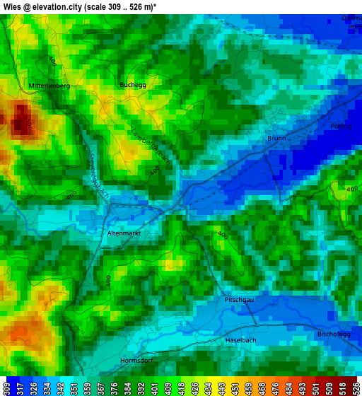
Below is the Elevation map of Wies, which displays elevation range with different colors. Scale of the first map is from 309 to 526 m (1014 to 1726 ft) with average elevation of 376.9 meters (=1237 ft) [note 1]
These maps also provides idea of topography and contour of this city, they are displayed at different zoom levels. More info about maps, scale and edge coordinates you can find below images.
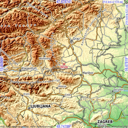
| \ | Map #1 | Topo.Map |
| Scale [m] | 309..526 m | × |
| Scale [ft] | 1014..1726 ft | × |
| Average | 376.9 m = 1237 ft | × |
| Width | 6.7 km = 4.2 mi | 214.4 km = 133.2 mi |
| Height | 6.7 km = 4.2 mi | 214.4 km = 133.2 mi |
| ↑Max Latitude | 46.750399° | 47.67574° |
| Latitude at center | 46.72028° | 46.72028° |
| ↓Min Latitude | 46.690144° | 45.74759° |
| ← Min Longitude | 15.227995° | 13.86569° |
| Longitude center | 15.27194° | 15.27194° |
| →Max Longitude | 15.315885° | 16.67819° |
Nearby cities:
Cities around Wies sort by population:
• Eibiswald elevation 371 m
4.2 km,  206°
206°
• Schwanberg 401 m
6.4 km,  311°
311°
• Brunn 330 m
2.4 km,  64°
64°
• Gleinstätten 298 m
8.3 km, 63°
• Oberhaag 324 m
5.9 km,  129°
129°
• Pistorf 321 m
8.9 km,  54°
54°
• Aibl 382 m
5.6 km,  218°
218°
• Sankt Peter im Sulmtal 410 m
3.7 km,  333°
333°
• Hollenegg 470 m
9.1 km, 330°
• Pitschgau 352 m
2.3 km,  190°
190°
• Wernersdorf 383 m
5 km,  264°
264°
• Sankt Martin im Sulmtal 336 m
4.4 km,  25°
25°
Multilingual:
 En español:
Wies elevación 334 m.
 En France:
Wies élévation 334 m.


Sources and notes:
- [note 1] Map square and city borders are not equal. Map elevation data is calculated only from area inside that square.
- [src 1] Elevation data from geonames database provided with same terms of usage.
- [src 2] The elevation map of Wies is generated using elevation data from NASA's 3 arcsec (90m) resolution SRTM data.
- [src 3] Base (background) map © OpenStreetMap contributors tiles are generated by Geofabrik and OpenTopoMap.
Copyright & License:
This Wies Elevation Map is licensed under CC BY-SA. You may reuse any part from this page, if you give a proper credit by linking to this URL:
 More info on terms of use page.