Windhag elevation
Windhag (Lower Austria, Waidhofen an der Ybbs Stadt), Austria elevation is 702 meters and Windhag elevation in feet is 2303 ft above sea level [src 1]. Windhag is a populated place (feature code) with elevation that is 193 meters (633 ft) bigger than average city elevation in Austria.
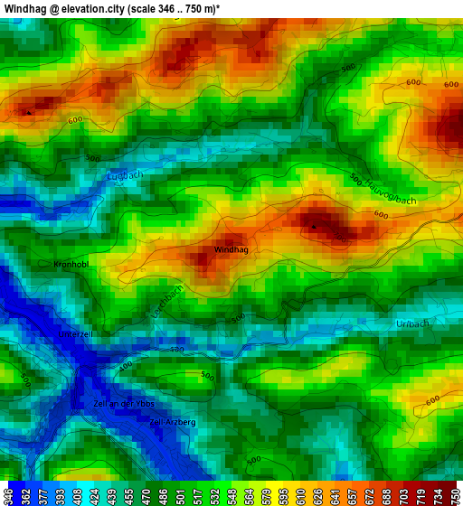
Below is the Elevation map of Windhag, which displays elevation range with different colors. Scale of the first map is from 346 to 750 m (1135 to 2461 ft) with average elevation of 516.7 meters (=1695 ft) [note 1]
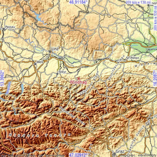
These maps also provides idea of topography and contour of this city, they are displayed at different zoom levels. More info about maps, scale and edge coordinates you can find below images.
| \ | Map #1 | Topo.Map |
| Scale [m] | 346..750 m | × |
| Scale [ft] | 1135..2461 ft | × |
| Average | 516.7 m = 1695 ft | × |
| Width | 6.54 km = 4.1 mi | 209.3 km = 130.1 mi |
| Height | 6.54 km = 4.1 mi | 209.3 km = 130.1 mi |
| ↑Max Latitude | 48.008469° | 48.91184° |
| Latitude at center | 47.97906° | 47.97906° |
| ↓Min Latitude | 47.949635° | 47.02912° |
| ← Min Longitude | 14.758505° | 13.3962° |
| Longitude center | 14.80245° | 14.80245° |
| →Max Longitude | 14.846395° | 16.2087° |
Nearby cities:
Cities around Windhag sort by population:
• Waidhofen an der Ybbs elevation 360 m
3 km,  225°
225°
• Kematen an der Ybbs 316 m
5.9 km,  331°
331°
• Biberbach 356 m
9 km,  308°
308°
• Hausmening 303 m
10.2 km,  4°
4°
• Ybbsitz 411 m
7.5 km,  117°
117°
• Zell-Arzberg 377 m
3.1 km,  192°
192°
• Rosenau am Sonntagberg 340 m
5.7 km,  304°
304°
• Zell-Markt 363 m
2.7 km,  212°
212°
• Neuhofen an der Ybbs 318 m
9.6 km,  23°
23°
• Allhartsberg 390 m
5.3 km,  350°
350°
• Gaflenz 476 m
11 km, 211°
• Sonntagberg 680 m
3.6 km, 300°
Multilingual:
 En español:
Windhag elevación 702 m.
 En France:
Windhag élévation 702 m.


Sources and notes:
- [note 1] Map square and city borders are not equal. Map elevation data is calculated only from area inside that square.
- [src 1] Elevation data from geonames database provided with same terms of usage.
- [src 2] The elevation map of Windhag is generated using elevation data from NASA's 3 arcsec (90m) resolution SRTM data.
- [src 3] Base (background) map © OpenStreetMap contributors tiles are generated by Geofabrik and OpenTopoMap.
Copyright & License:
This Windhag Elevation Map is licensed under CC BY-SA. You may reuse any part from this page, if you give a proper credit by linking to this URL:
 More info on terms of use page.