Wolfsbach elevation
Wolfsbach (Lower Austria, Politischer Bezirk Amstetten), Austria elevation is 337 meters and Wolfsbach elevation in feet is 1106 ft above sea level [src 1]. Wolfsbach is a seat of a third-order administrative division (feature code) with elevation that is 172 meters (564 ft) smaller than average city elevation in Austria.
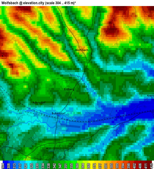
Below is the Elevation map of Wolfsbach, which displays elevation range with different colors. Scale of the first map is from 304 to 415 m (997 to 1362 ft) with average elevation of 344.2 meters (=1129 ft) [note 1]
These maps also provides idea of topography and contour of this city, they are displayed at different zoom levels. More info about maps, scale and edge coordinates you can find below images.
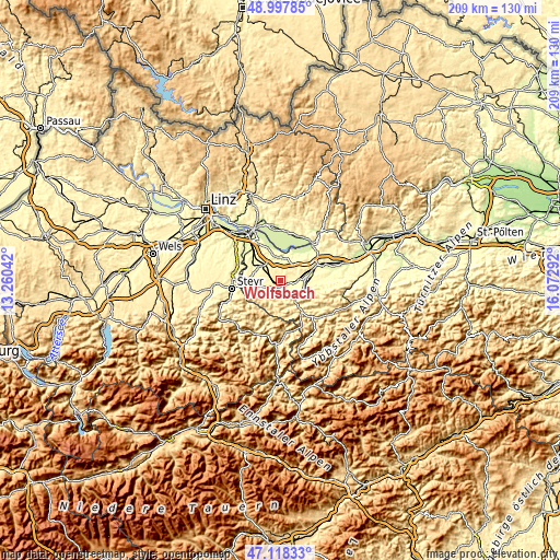
| \ | Map #1 | Topo.Map |
| Scale [m] | 304..415 m | × |
| Scale [ft] | 997..1362 ft | × |
| Average | 344.2 m = 1129 ft | × |
| Width | 6.53 km = 4.1 mi | 209 km = 129.9 mi |
| Height | 6.53 km = 4.1 mi | 209 km = 129.9 mi |
| ↑Max Latitude | 48.096029° | 48.99785° |
| Latitude at center | 48.06667° | 48.06667° |
| ↓Min Latitude | 48.037294° | 47.11833° |
| ← Min Longitude | 14.622725° | 13.26042° |
| Longitude center | 14.66667° | 14.66667° |
| →Max Longitude | 14.710615° | 16.07292° |
Nearby cities:
Cities around Wolfsbach sort by population:
• Seitenstetten Markt elevation 345 m
3.9 km,  198°
198°
• Haag 323 m
9 km,  305°
305°
• Kematen an der Ybbs 316 m
8.6 km,  122°
122°
• Mauer bei Amstetten 298 m
10.5 km,  71°
71°
• Biberbach 356 m
5.1 km,  142°
142°
• Weistrach 356 m
6.5 km,  253°
253°
• Sankt Peter in der Au Markt 353 m
4.2 km,  232°
232°
• Aschbach Markt 307 m
6.5 km,  84°
84°
• Ertl 442 m
10.3 km,  194°
194°
• Rosenau am Sonntagberg 340 m
8.5 km, 140°
• Allhartsberg 390 m
10.2 km, 116°
• Strengberg 327 m
9 km,  352°
352°
Multilingual:
 En español:
Wolfsbach elevación 337 m.
 En France:
Wolfsbach élévation 337 m.
 Auf Deutsch:
Wolfsbach höhe über dem Meeresspiegel ist 337 m.

Sources and notes:
- [note 1] Map square and city borders are not equal. Map elevation data is calculated only from area inside that square.
- [src 1] Elevation data from geonames database provided with same terms of usage.
- [src 2] The elevation map of Wolfsbach is generated using elevation data from NASA's 3 arcsec (90m) resolution SRTM data.
- [src 3] Base (background) map © OpenStreetMap contributors tiles are generated by Geofabrik and OpenTopoMap.
Copyright & License:
This Wolfsbach Elevation Map is licensed under CC BY-SA. You may reuse any part from this page, if you give a proper credit by linking to this URL:
 More info on terms of use page.