Zell am Ziller elevation
Zell am Ziller (Tyrol, Politischer Bezirk Schwaz), Austria elevation is 578 meters and Zell am Ziller elevation in feet is 1896 ft above sea level [src 1]. Zell am Ziller is a seat of a third-order administrative division (feature code) with elevation that is 69 meters (226 ft) bigger than average city elevation in Austria.
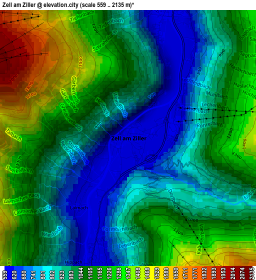
Below is the Elevation map of Zell am Ziller, which displays elevation range with different colors. Scale of the first map is from 559 to 2135 m (1834 to 7005 ft) with average elevation of 1048.2 meters (=3439 ft) [note 1]
These maps also provides idea of topography and contour of this city, they are displayed at different zoom levels. More info about maps, scale and edge coordinates you can find below images.
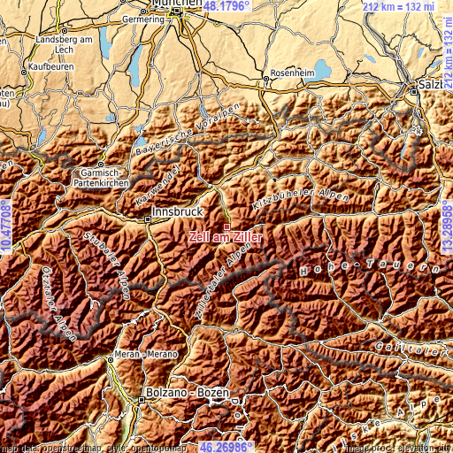
| \ | Map #1 | Topo.Map |
| Scale [m] | 559..2135 m | × |
| Scale [ft] | 1834..7005 ft | × |
| Average | 1048.2 m = 3439 ft | × |
| Width | 6.64 km = 4.1 mi | 212.3 km = 131.9 mi |
| Height | 6.64 km = 4.1 mi | 212.3 km = 131.9 mi |
| ↑Max Latitude | 47.263161° | 48.1796° |
| Latitude at center | 47.23333° | 47.23333° |
| ↓Min Latitude | 47.203482° | 46.26986° |
| ← Min Longitude | 11.839385° | 10.47708° |
| Longitude center | 11.88333° | 11.88333° |
| →Max Longitude | 11.927275° | 13.28958° |
Nearby cities:
Cities around Zell am Ziller sort by population:
• Stumm elevation 557 m
6.4 km,  2°
2°
• Aschau im Zillertal 573 m
3.8 km,  13°
13°
• Schwendau 618 m
4.4 km,  204°
204°
• Aschau 561 m
3.9 km,  18°
18°
• Ramsau im Zillertal 600 m
3.3 km,  190°
190°
• Hippach 604 m
3.5 km, 202°
• Kaltenbach 930 m
5.7 km,  347°
347°
• Hainzenberg 926 m
2.1 km,  143°
143°
• Rohrberg 1201 m
2.5 km,  90°
90°
• Stummerberg 1160 m
6.1 km, 24°
• Gerlosberg 911 m
4.2 km,  116°
116°
• Zellberg 1322 m
2.5 km,  270°
270°
Multilingual:
 En español:
Zell am Ziller elevación 578 m.
 En France:
Zell am Ziller élévation 578 m.
 Auf Deutsch:
Zell am Ziller höhe über dem Meeresspiegel ist 578 m.

Sources and notes:
- [note 1] Map square and city borders are not equal. Map elevation data is calculated only from area inside that square.
- [src 1] Elevation data from geonames database provided with same terms of usage.
- [src 2] The elevation map of Zell am Ziller is generated using elevation data from NASA's 3 arcsec (90m) resolution SRTM data.
- [src 3] Base (background) map © OpenStreetMap contributors tiles are generated by Geofabrik and OpenTopoMap.
Copyright & License:
This Zell am Ziller Elevation Map is licensed under CC BY-SA. You may reuse any part from this page, if you give a proper credit by linking to this URL:
 More info on terms of use page.