Zerlach elevation
Zerlach (Styria, Politischer Bezirk Südoststeiermark), Austria elevation is 336 meters and Zerlach elevation in feet is 1102 ft above sea level [src 1]. Zerlach is a seat of a third-order administrative division (feature code) with elevation that is 173 meters (568 ft) smaller than average city elevation in Austria.
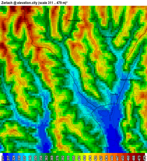
Below is the Elevation map of Zerlach, which displays elevation range with different colors. Scale of the first map is from 311 to 479 m (1020 to 1572 ft) with average elevation of 382.7 meters (=1256 ft) [note 1]
These maps also provides idea of topography and contour of this city, they are displayed at different zoom levels. More info about maps, scale and edge coordinates you can find below images.
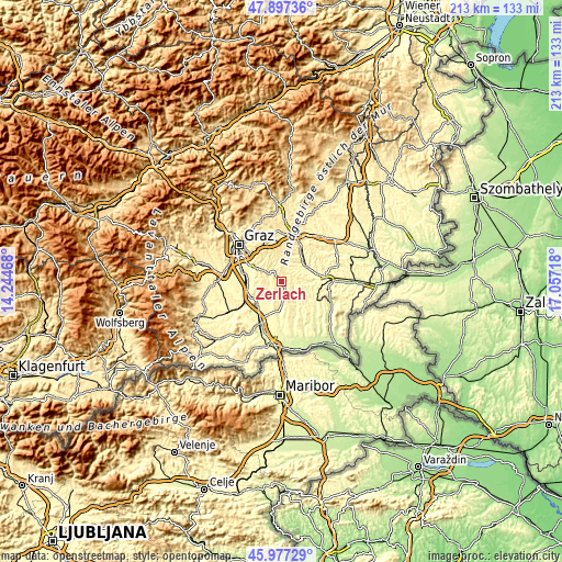
| \ | Map #1 | Topo.Map |
| Scale [m] | 311..479 m | × |
| Scale [ft] | 1020..1572 ft | × |
| Average | 382.7 m = 1256 ft | × |
| Width | 6.67 km = 4.1 mi | 213.5 km = 132.7 mi |
| Height | 6.67 km = 4.1 mi | 213.5 km = 132.7 mi |
| ↑Max Latitude | 46.975923° | 47.89736° |
| Latitude at center | 46.94593° | 46.94593° |
| ↓Min Latitude | 46.915921° | 45.97729° |
| ← Min Longitude | 15.606985° | 14.24468° |
| Longitude center | 15.65093° | 15.65093° |
| →Max Longitude | 15.694875° | 17.05718° |
Nearby cities:
Cities around Zerlach sort by population:
• Sankt Stefan im Rosental elevation 327 m
6.5 km,  136°
136°
• Heiligenkreuz am Waasen 323 m
4.9 km,  282°
282°
• Allerheiligen bei Wildon 393 m
8.1 km,  244°
244°
• Kirchbach in Steiermark 333 m
1.8 km,  152°
152°
• Pirching am Traubenberg 354 m
3.9 km, 276°
• Empersdorf 359 m
7.1 km,  326°
326°
• Oberdorf am Hochegg 360 m
6.5 km,  55°
55°
• Edelstauden 404 m
4.9 km, 327°
• Schwarzau im Schwarzautal 297 m
7.5 km,  172°
172°
• Mitterlabill 312 m
6.4 km,  190°
190°
• Frannach 319 m
3.9 km,  199°
199°
• Sankt Marein bei Graz 358 m
8.2 km,  17°
17°
Multilingual:
 En español:
Zerlach elevación 336 m.
 En France:
Zerlach élévation 336 m.


Sources and notes:
- [note 1] Map square and city borders are not equal. Map elevation data is calculated only from area inside that square.
- [src 1] Elevation data from geonames database provided with same terms of usage.
- [src 2] The elevation map of Zerlach is generated using elevation data from NASA's 3 arcsec (90m) resolution SRTM data.
- [src 3] Base (background) map © OpenStreetMap contributors tiles are generated by Geofabrik and OpenTopoMap.
Copyright & License:
This Zerlach Elevation Map is licensed under CC BY-SA. You may reuse any part from this page, if you give a proper credit by linking to this URL:
 More info on terms of use page.