Tāfuna elevation
Tāfuna (Western District), American Samoa elevation is 13 meters and Tāfuna elevation in feet is 43 ft above sea level [src 1]. Tāfuna is a populated place (feature code) with elevation that is 33 meters (108 ft) smaller than average city elevation in American Samoa.
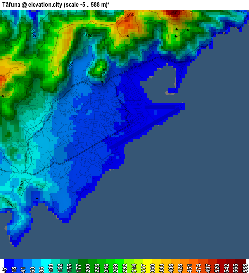
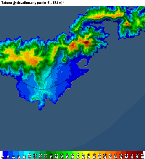
Below is the Elevation map of Tāfuna, which displays elevation range with different colors. Scale of the first map is from -5 to 588 m (-16 to 1929 ft) with average elevation of 125.4 meters (=411 ft) [note 1]
These maps also provides idea of topography and contour of this city, they are displayed at different zoom levels. More info about maps, scale and edge coordinates you can find below images.
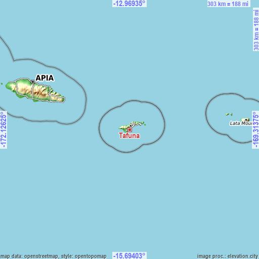
| \ | Map #1 | Map #2 | Topo.Map |
| Scale [m] | -5..588 m | -5..588 m | × |
| Scale [ft] | -16..1929 ft | -16..1929 ft | × |
| Average | 125.4 m = 411 ft | 148.6 m = 488 ft | × |
| Width | 9.47 km = 5.9 mi | 18.94 km = 11.8 mi | 303 km = 188.3 mi |
| Height | 9.47 km = 5.9 mi | 18.94 km = 11.8 mi | 303 km = 188.3 mi |
| ↑Max Latitude | -14.293249° | -14.25066° | -12.96935° |
| Latitude at center | -14.33583° | -14.33583° | -14.33583° |
| ↓Min Latitude | -14.378403° | -14.420968° | -15.69403° |
| ← Min Longitude | -170.763945° | -170.807891° | -172.12625° |
| Longitude center | -170.72° | -170.72° | -170.72° |
| →Max Longitude | -170.676055° | -170.632109° | -169.31375° |
Nearby cities:
Cities around Tāfuna sort by population:
• Pago Pago elevation 144 m
6.7 km,  16°
16°
• Leone 21 m
7.1 km,  262°
262°
• Faleniu 53 m
2.7 km,  278°
278°
• Aūa 19 m
9 km,  42°
42°
• Mapusagafou 111 m
3.6 km, 279°
• Fagatogo 141 m
6.8 km,  28°
28°
• Vaitogi 16 m
3 km,  211°
211°
• Malaeimi 41 m
2.1 km,  314°
314°
• Vailoatai 16 m
7.3 km,  247°
247°
• Ta`ū 12 m
130.4 km,  84°
84°
• Ofu 17 m
113.8 km, 80°
• Faleāsao 28 m
130.7 km, 84°
Multilingual:
 En español:
Tāfuna elevación 13 m.
 En France:
Tāfuna élévation 13 m.


Sources and notes:
- [note 1] Map square and city borders are not equal. Map elevation data is calculated only from area inside that square.
- [src 1] Elevation data from geonames database provided with same terms of usage.
- [src 2] The elevation map of Tāfuna is generated using elevation data from NASA's 3 arcsec (90m) resolution SRTM data.
- [src 3] Base (background) map © OpenStreetMap contributors tiles are generated by Geofabrik and OpenTopoMap.
Copyright & License:
This Tāfuna Elevation Map is licensed under CC BY-SA. You may reuse any part from this page, if you give a proper credit by linking to this URL:
 More info on terms of use page.